Presque Isle State Park is a 3,200-acre sandy peninsula that extends into Lake Erie and is the state’s only “seashore.” It offers a beautiful coastline and many year round recreational activities, including swimming, boating, fishing, hiking, bicycling, and in-line skating. It is a significant birding hotspot. The Tom Ridge Environmental Center is near the entrance to the park.
The neck of the peninsula is attached to the mainland four miles west of downtown Erie. The peninsula creates Presque Isle Bay, a wide and deep harbor for the city of Erie. The bay attracts many pleasure boats and worldwide freight traffic, making Erie an important Great Lakes shipping port.
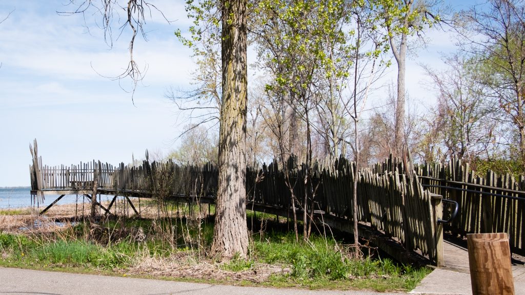
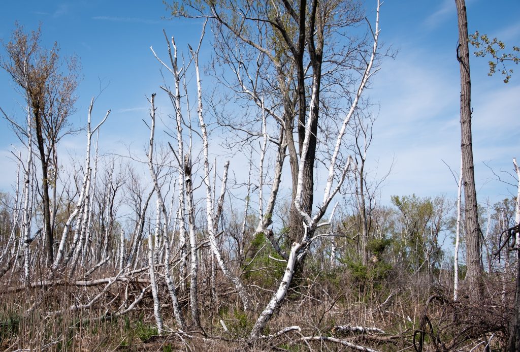
A National Natural Landmark, Presque Isle is a favorite spot for migrating birds. Because of the many unique habitats, Presque Isle contains a greater number of the state’s endangered, threatened, and rare species than any other area of comparable size in Pennsylvania.
The North Pier Lighthouse.The Presque Isle Lighthouse.These structures take the term ‘houseboat” literally.The Perry MonumentSome views of wetland habitat that are so valuable for birds and other critters.
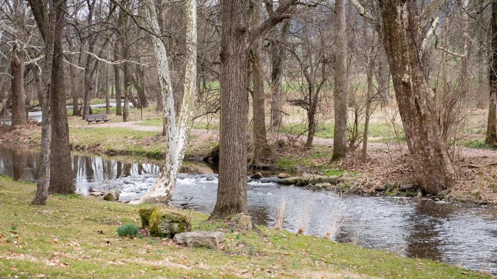
West along the shores of Lake Erie is the 587-acre Erie Bluffs State Park. The park offers one mile of shoreline, 90-foot bluffs overlooking Lake Erie, and access to Elk Creek, a shallow stream steelhead fishery. Significant natural features include several plant species of conservation concern, uncommon black oak woodland/savannah habitat, Great Lakes region sand barren ecosystems, and forested wetlands.
The Elk Creek access area provides fishing and boat launch areas.
Oil Creek State Park lies in northwestern Pennsylvania in the Oil Creek Valley. It is the site of the world’s first commercial oil well. The park preserves the history of the early petroleum industry by interpreting oil boomtowns, oil wells, and early transportation. The scenic creek carves a valley of deep hollows, steep hillsides, and wetlands and provides opportunities for kayaking, wildlife watching and fishing. Hiking is a popular activity here, and a 36 mile loop trail has two shelter areas that support backpackers.
At the time of my visit, work on the Petroleum Center Bridge blocked egress through the park. However, following the detour to the other side of the park is well worthwhile.
The site of the former Petroleum Center Train Station.Can’t get there from here.
On the hill above Oil City is Murray’s Scenic View, overlooking the city and Oil Creek. It is a very nice view, and there is even a small restaurant for a drink or a snack.
One of Pennsylvania’s iconic state parks is Kinzua Bridge. There is a large visitor center and an opportunity to walk out onto the old railroad viaduct with impressive views of the valley below.
The Viaduct was once the longest and tallest railroad structure at 2,053 feet long and 301 feet high. It was partially destroyed by a tornado during 2003. Reinvented as a pedestrian walkway in 2011, visitors can stroll 600 feet out on the remaining support towers, peer miles out into the Kinzua Gorge, and gaze down through the partial glass platform at the end of the walkway. The Kinzua Bridge State Park Visitor Center features great views, self-guiding exhibits, and information about the surrounding area.
A view to the valley below. This photo really doesn’t do it justice.Some exhibits in the Visitor’s Center.A unexpected photo op – the Swedish Viking Ship sculpture in nearby Mt. Jewett.
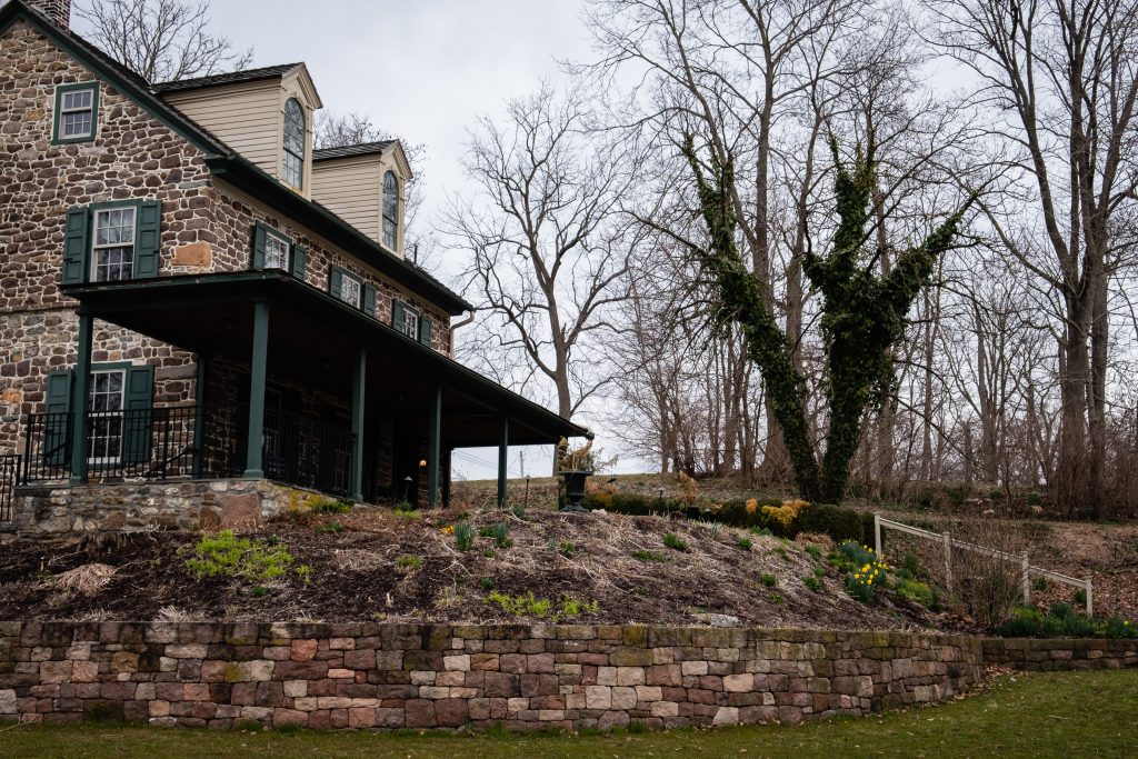
A day out in the rural areas of Lancaster County will provide many encounters with horse drawn buggies, whether in motion or stationery. Sundays tend to be particularly busy, with people going to church or visiting neighbors.
A small child looks on …Traffic Gap with a miniature of the Clock Tower (full size below).People who drive buggies need to shop too. Stores in the area often have hitches, or even simple open sheds, for horse parking.
The Ephrata Cloister or Ephrata Community was a religious community, established in 1732 by Johann Conrad Beissel at Ephrata, Lancaster County. The grounds of the community are now owned by the Commonwealth of Pennsylvania and are administered by the Pennsylvania Historical and Museum Commission. The Cloister’s website can be found at https://ephratacloister.org and provides the following information:
Conrad Beissel, Ephrata’s founder, came to the site in 1732 seeking to live as a hermit following his own religious ideas. He believed earthly life should be spent preparing to achieve a spiritual union with God at the Second Coming he felt would soon occur. By the early 1750s, nearly 80 celibate Brothers and Sisters were housed in impressive Germanic log, stone, and half-timbered buildings. At the same time, nearly 200 family members known as Householders, occupied nearby homes and farms.
Celibate members followed a life of work balanced with hours of private prayer. Wearing white robes, they adopted sparse diets, and slept little, all in an effort to provide discipline as they prepared for an anticipated heavenly existence. Labors included farming, papermaking, carpentry, milling, and textile production. The Cloister was known for the German calligraphic art of Frakturschriften, created in a distinctive style considered the first of this folk art produced in America, self-composed a cappella music written using Beissel’s rules for four-part harmony (with over one-thousand original compositions), and an ambitious printing establishment creating works for the use of the community and neighbors, including the translation and publication of the 1500 page Martyrs Mirror for the Mennonites, the largest book printed in colonial America.
The Society declined after the death of the charismatic Beissel in 1768. The last celibate member died in 1813 and the next year the remaining Householders incorporated into the German Seventh Day Baptist Church. Members continued to live and worship in the Cloister buildings until the close of the Church in 1934. Marie Kachel Bucher, the last surviving resident of the Ephrata Cloister, died on July 27, 2008, at the age of 98.
Here is a look at the exterior of the buildings. There was an event going on that Day called “Charter Day” which was wrapping up as I was arriving in late afternoon.
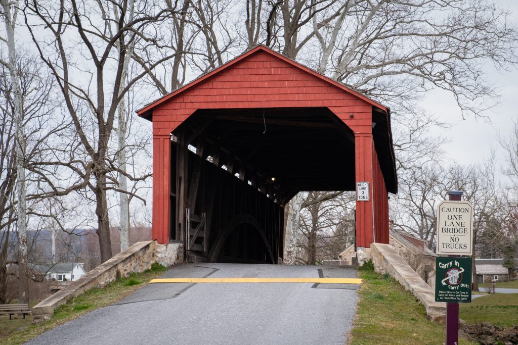
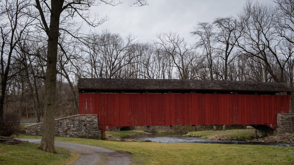
It’s not that often that one comes across a covered bridge with an associated historic site. Poole Forge, in Eastern Lancaster County, is just such a place. The 26-acre site also has a preserved historic Ironmaster’s mansion, children’s playground, picnic pavilion, ball field, Nature Trail, Riparian Buffers, wildflower meadows, and many beautiful gardens along the Conestoga River. It is a national historic district and was listed on the National Register of Historic Places in 1993.
Poole Forge was part of the iron industry in Lancaster and nearby counties. James Old, a Welshman and iron master, purchased the property in 1775. He established and operated a forge here for twenty years. The pig iron was obtained from nearby furnaces such as Hopewell, Joanna, Elizabeth, and Cornwall. Poole Forge refined the iron, then sold it to blacksmiths, or sent it to markets in Philadelphia, where it was used to make armaments for the Revolutionary War. In 1795, he sold the forge to his son, Davis Old, and over the next half century, it continued operation through many changes of hands. In 1852, iron production was ended. The covered bridge dates to 1859.
First up are views of the covered bridge:
There are multiple fine Federal style buildings at this site.
Valley Forge is one of my most photographed areas. I just can’t help myself. The first location is Lord Stirling’s Quarters. I have long wanted to photograph these buildings but have not been able until recently. Unfortunately, like most park locations, these buildings are not open to the public and not in good repair. Valley Forge is sadly underfunded, like most of our national park system.
The next area is known as the Artillery Park. I bird and photograph around here a lot.
Finally, this foot bridge is near the top of Mount Joy
An day drive around the lovely Kimberton area of Chester County. As they say, “A picture is worth a thousand words.”
An old ruin along a creek, near the Kennedy Covered BridgeThe “Historical” Seven Star InnA couple of hooved friends on a warm winter’s day ….They are everywhere this time of year.Really nice barnStruble Lake in northwestern Chester County – definitely not in Kimberton.
This post features a quick series of covered bridges in northwestern Lancaster County, the home of the largest number of covered bridges in the state. The first up is Schenk’s Mill Covered Bridge (or Shenk’s Mill Covered Bridge). It is a covered bridge that spans Big Chiques Creek. The bridge has a single span, wooden, double Burr arch truss design with the addition of steel hanger rods. The deck is made from oak planks. It is painted red and both approaches to the bridge are painted white. It is one of only 3 covered bridges in the county with horizontal side boards. It is listed on the National Register of Historic Places. The bridge was built in 1847 by Charles Malhorn and Levi Fink. It was rebuilt in 1855 and is 80 feet long.
Shenk’s Mill Covered Bridge
The Shearer’s Covered Bridge is a covered bridge that also spans Big Chiques Creek. The bridge has a single span, wooden, double Burr arch truss design. It is the only covered bridge in the county painted entirely in red in Lancaster County, on both the inside and outside, including both approaches. The other all red bridge, Pool Forge Covered Bridge, is only painted on the outside. It is one of only 3 covered bridges in the county with horizontal side boards. It is listed on the National Register of Historic Places. The bridge was built in 1847 by Jacob Clare. It was rebuilt in 1855 and stayed its original location until it was moved in 1971 to its present location in the Manheim Memorial Park. It is 86 feet long.
Shearer’s Mill Covered Bridge
The Pinetown Bushong’s Mill Covered Bridge is a covered bridge that spans the Conestoga River. The bridge is also known as the Pinetown Amish Covered Bridge, Pinetown Covered Bridge, Nolte’s Point Mill Bridge and Bushong’s Mill Bridge.
The bridge has a single span, wooden, double Burr arch truss design with the addition of steel hanger rods. The deck is made from oak planks. It is listed on the National Register of Historic Places. The bridge was built in 1867 by Elias McMellen at a cost of $4,500. In 1972, it was destroyed as a result of flooding caused by Hurricane Agnes. Due to a tremendous response of area residents who signed a petition for its reconstruction, it was among the first covered bridges to be restored after Agnes. In the spring of 1973, the bridge was rebuilt by the nearby Amish. To prevent damage due to future flooding, they raised the bridge to 17 feet 6 inches above the average water line. Lititz Run joins the Conestoga River at this site. It is 124 feet long.
Pinetown Amish Covered Bridge
The Kauffman’s Distillery Covered Bridge, or Sporting Hill Bridge, is a covered bridge that spans Chiques Creek. The bridge has a single span, wooden, double Burr arch truss design with the addition of steel hanger rods. The deck is made from oak planks.
It is registered on the National Register of Historic Places. Kauffman’s Distillery Covered Bridge was originally built in 1857 at a cost of $1,185 by James C. Carpenter. The bridge was named after the Kauffman’s Distillery Mill which operated in the late 1800s. In 1874, the bridge was rebuilt by Elias McMellen at a cost of $1,620. It is 84 feet long.
Kauffman’s Distillery Covered Bridge
Hunsecker’s Mill Covered Bridge is a covered bridge located in Lancaster County, Pennsylvania, United States. The bridge has a single span, wooden, double Burr arch truss design. The bridge, which spans the Conestoga River, is 180 feet long, making it the longest single span covered bridge in the county. The original bridge was built in 1843 by John Russell at a cost of $1,988. It is a double Burr Arch truss system. It has been swept away in flooding numerous times, most recently in 1972 after Hurricane Agnes. Waters lifted the original structure off its abutments and carried it downstream. In 1973, following destruction from the hurricane, it was rebuilt at a cost of $321,302. While Schenck’s covered bridge is one of 3 bridges with horizontal siding boards, the Hunsecker’s Mill bridge may be the only one in Lancaster County with horizontal floor boards which give a unique vibration upon crossing. A detailed scale model (~7′ long), complete with stone abutments, was donated to the Lancaster Mennonite Historical Society and may be available for viewing.
Hunsecker’s Mill Covered Bridge
Erb’s Mill Covered Bridge is a covered bridge that spans Hammer Creek. The bridge has a single span, wooden, double Burr arch truss design with the addition of steel hanger rods. The deck is made from oak planks. It was added to the National Register of Historic Places in 1980. The bridge was originally built in 1849 for a cost of $700. It was built on the Erb family’s tract of land in the farming region along Hammer Creek. In 1887 the bridge was rebuilt by John G. Bowman for $1744. It is 70 feet long.
Erb’s Mill Covered Bridge
The Bucher’s Mill Covered Bridge (or Butcher’s Mill Covered Bridge) is a covered bridge that spans Cocalico Creek. After the Landis Mill Covered Bridge, it is the second shortest covered bridge in the county. The bridge has a single span, wooden, double Burr arch truss design with the addition of steel hanger rods. The deck is made from oak planks.
It is registered on the National Register of Historic Places. Bucher’s Mill Covered Bridge was built in 1891 by Elias McMellen, using single span, wooden, double Burr arch truss construction, at a cost of $1167. A year later, in 1892, the bridge was damaged heavily in a flood and was rebuilt by McMellen for $1025. At only 64 feet long, it is one of the shortest covered bridges in Lancaster County.
In 1996, Charlestown Township in Chester County purchased 20 acres of the Brightside Farm located to preserve it from impending development. The Township added 55 additional acres to Brightside Farm Park with the purchase of the rest of the farm with the help of a significant grant from Chester County in the year 2000. The farm is preserved as an agricultural asset for the residents to enjoy, and a portion of the property is under a conservation easement with the French & Pickering Creeks Trust. The park offers over 50 garden plots to township residents and has walking trails.
A view of the barn.And another …Near by farmhouse and barn.
A feature in the Park is the Wisner Rapp House. Jacob Wisner House, also known as the Rapp House, is a historic home that was built in two sections. The older section dates to 1761, and is a 2 1/1-story, three bay wide, stone structure. A two bay wide extension was added in the 1840s. The addition was originally built to house a saddle and harness-maker’s shop and later housed the Sidley Post Office.