

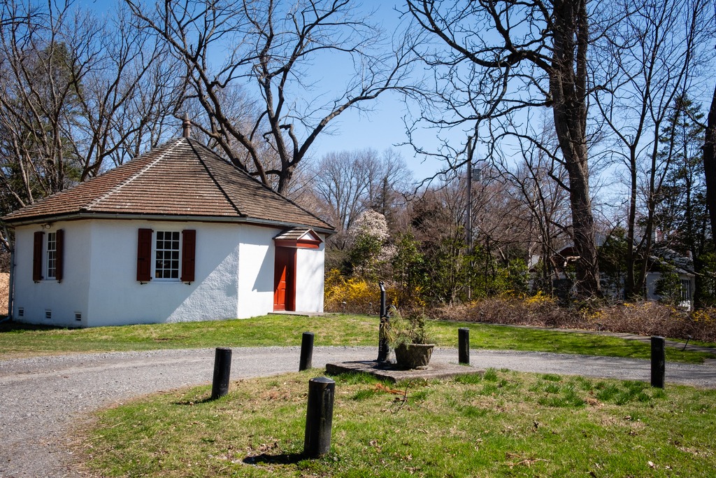
Vosburg Neck State Park has some lovely natural areas, in addition to the park facilities. Below are some more scenes from my visit. The birding was also very good here, and I had over 50 species during my trip here.


Vosburg Neck State Park has some lovely natural areas, in addition to the park facilities. Below are some more scenes from my visit. The birding was also very good here, and I had over 50 species during my trip here.
Vosburg Neck State Park lies five miles west of Tunkhannock in Wyoming County. The park’s 669 acres feature historic buildings from the 1700 and 1800s, a canal bed and rail bed,, and a 1700s-era cemetery. Recreational activities include eight miles of trails, non-motorized boating access, and picnic areas.
The park is one of Pennsylvania’s three new state parks, and the most developed to date. The park was formerly the Howland Preserve. It is located in an oxbow on the north branch of the Susquehanna River known as the Vosburg Neck and features a diverse range of habitat.


Last week we visited the N.C. Wyeth House and Studio. The nearby Andrew Wyeth Studio can also be visited via a tour from Brandywine Museum of Art. The site is described on brandywine.org as:
Andrew Wyeth, one of America’s best-known twentieth-century artists, painted many of his most important works of art in his Chadds Ford studio. Given to the Brandywine Museum of Art by the artist’s wife, Betsy James Wyeth, the studio provides visitors with a unique opportunity to experience this very personal space…. This studio, a repurposed schoolhouse originally built in 1875, served as the artist’s principal Pennsylvania workplace from 1940 to 2008. Thousands of paintings and drawings were created there, inspired by the people, architecture and landscapes of Chadds Ford. The studio still houses the furnishings, library and collections acquired by the artist, as well as examples of the art materials he used throughout his career.


The site is only available on limited dates and times, so please check with the Brandywine Museum of Art for more details.
The N.C. Wyeth House and Studio makes a lovely trip in the early Spring. One can visit the house and studio via a guided tour which leaves from the Brandywine River Museum and is definitely a must see for Wyeth fans. N.C. Wyeth is primarily known as an illustrator but worked on other subject matter as well. The property is only available for tours with limited dates and times, so please check the website at brandwyine.org for more information.
The site is described on the website as follows: In 1911, with the proceeds from his illustrations for Treasure Island, the artist N.C. Wyeth purchased 18 acres of land near the village of Chadds Ford, Pennsylvania. Possessed, he described it as “the most glorious site in the township.”
The house and studio, located five minutes from the museum, retain much of their original character. The main studio, with its spectacular Palladian-style north window, still contains many of the props that were essential to the work of an illustrator, including a birch-bark canoe and a collection of firearms. A full-size mural painting, displayed in a soaring 1923 addition, helps tell the story of Wyeth’s career. The house, with its country furnishings, reveals a more intimate picture of family life.
The N.C. Wyeth House and Studio is a National Historic Landmark and a member of the Historic Artists’ Homes and Studios program of the National Trust for Historic Preservation.


I recently started watching the “Franklin” TV series on Apple TV+ which mentions the injury to the Marquis de Lafayette during the Battle of Brandywine. Coincidentally, I had visited part of the battlefield site a few weeks before.
The Brandywine Battlefield Historic Site is a National Historical Landmark which is owned and operated by the Pennsylvania Historical and Museum Commission, on 52 acres (210,000 m2), near Chadds Ford, Delaware County. This area is a partial site of the Battle of Brandywine, which was fought on September 11, 1777. The battle was a decisive victory for the British and cleared a path directly to the capital in Philadelphia.
Brandywine Battlefield Park became a Pennsylvania State Park in 1949 and a National Historic Landmark in 1961. Although the battle area covered more than ten square miles, or 35,000 acres, the modern park only covers the fifty acres that served primarily as the Continental encampment during the two days prior to the battle. To the north, another part of the battlefield is maintained by Birmingham Township, Chester County as “Battlefield of the Brandywine Park,” or “Sandy Hollow Heritage Park.” Much of the afternoon’s fighting took place between Birmingham Friends Meetinghouse and the William Brinton 1704 House near Dilworthtown. A subsequent engagement occurred during the Battle of Paoli. The Paoli Battlefield Historical Park and Paoli Memorial Grounds are located in Malvern.
The site is operated under an agreement between the PHMC and Chadds Ford Township with the Brandywine Battlefield Associates, or “Friends of Brandywine Battlefield” who now operate the site with staff and volunteers. If you wish to visit this site, please check hours before going. I have frequently passed by the gates here, and they have been closed. This was a brief visit, as I was stopping by after a visit to the Brandywine River Museum, and I plan to return in the future.


The Gosheville Blacksmith Shop lies on Route 352 just south of Paoli Pike in Chester County. It is owned by East Goshen Township and is open Wednesday and Saturday from 10 am to 4 pm for viewing of the interior and and a working blacksmith. It is part of the Goshenville Historic District. While I was there, a young woman was working the forge and making small iron objects. She was also available to provide information about the site. Two rooms on the lower floor are available for viewing.
The Blacksmith Shop is described on the East Goshen Township website thusly:
The Goshenville Blacksmith Shop was built in 1740 by Arron Ashbridge (1712 – 1776) for rental as a wheelwright shop. The hearth room section was built first. Around 1750 Aaron’s son Joshua completed his apprenticeship at the Willistown Forge and opened his own blacksmithing business in this shop. At that time a one and half story addition was erected on the south side of the original building to house the wheelwright shop. Around 1800 the addition was reconstructed with a full second floor to be used as a room for painting wagons and carriages. Sometime in the 1800s the field stone building was covered with stucco (patches of the original stucco remain). It is interesting to point out that iron ore is mixed in with the field stones in the walls of the building…. In addition to horse shoeing, the blacksmith along with the wheelwright, repaired single and double trees for wagons, tightened and re-rimmed wagon wheels, built new hay wagon bodies on farmers running gear. The smith would also repair and sharpen farm tools, replaced wooden handles on shovels and forks and make fireplace andirons and household and farm tools. Often broken tools required welding by heating the parts in the forge then hammering the pieces together at the anvil.


The trip home was made by a different route. I headed north through Chester County toward Elverson from Hibernia County Park and then across Route 23.
Interesting pavilions at a park in Elverson.

This is a lovely area called Coventryville that I have photographed before. Coventryville was founded as an iron forge in 1717 by Englishman Samuel Nutt, an early American industrialist and member of Pennsylvania’s Assembly in 1723–26. Coventry was the first forge in Chester County and was located at the confluence of the north and south branches of French Creek, a short distance from rich iron deposits. Nutt went on to own two additional furnaces in partnership with Mordecai Lincoln and William Branson.
The village today consists of structures dating from the early 18th century until the mid 19th including workers housing, the Inn, the ironmaster’s house (Coventry Hall) and the mid 19th century Methodist church. The Coventryville Historic District remains an intact concentration of original eighteenth and nineteenth century structures. The community was listed on the National Register of Historic Places in 1978.

I love the big star on this barn.


Arriving at Hibernia County Park, I approached the main park area via Lyons Head Drive, a route I had never used before. There are some interesting older cottage style houses along this road, most of which are either off limits due to disrepair or privately occupied. At the top of the hill, I reached the Hibernia Mansion. The mansion is the former abode of local iron masters and a wealthy Philadelphia lawyer. It has expanded in the over the 200 years of its existence to meet the needs of its occupants.


This is a very nice old barn behind the mansion.


The Birmingham-Lafayette Cemetery in Chester County is a fascinating property. It lies near the Brandywine Battlefield historic site. It contains some interesting grave marker and memorials, including memorials to Generals Lafayette and Pulaski.


A short distance from the Chadds Ford area one enters the state of Delaware. Fred Smith’s Covered Bridge crosses the Brandywine Creek near the Brandywine tract of First State National Historic Park. It was reconstructed in 2002 after a fire in 1961. It is of the ever popular Burr Arch Truss design. The original Smith Bridge was built in 1839 and was a single span that crossed over Brandywine Creek, near Winterthur. It measured 154 feet long.


