On the last day of my trip to the Laurel Highland, I made a few stops at some covered bridges. Burkholder Covered Bridge was built in 1870 and uses the Burr Arch Truss in its construction. The bridge crosses Buffalo Creek in Brothers Valley Township, the length of the structure is 52 ft. and the width is 12 ft. It is in good condition and open to vehicle traffic.
Up next is the Packsaddle Covered Bridge. Packsaddle Covered Bridge (which is known as Doc Miller Covered Bridge in some sources) was built in 1870 by a builder that has been sadly lost to time. At 48 feet long, it is the shortest of the 10 covered bridges in Somerset County, PA. Don’t make my mistake and miss the small waterfall in Brush Creek under this bridge.
On my way back to the turnpike, I wanted to see the location of the Pittsburgh Zoo’s International Conservation Center. Unfortunately, it is not open to the public. It houses elephants that have been relocated from other facilities. This lovely church was on the way.
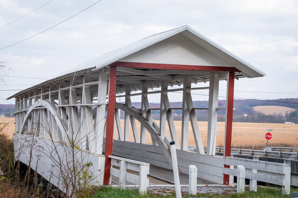
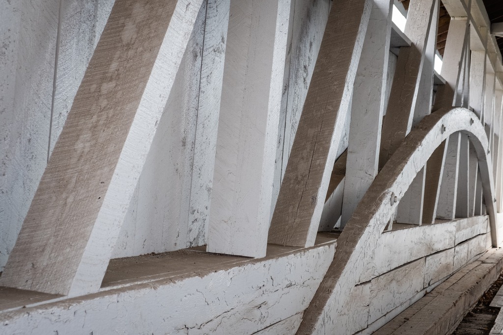
Somerset County is one of the places in Pennsylvania that has done an excellent job of preserving its covered bridges. They make nice side trips if you are visiting for skiing or other outdoor activity, Driving south in the county, one comes to Barronvale Covered Bridge. This bridge, also known as Barron’s Mill Bridge, is a covered bridge in Middlecreek Township crossing Laurel Hill Creek. At 162 feet 3 inches (49.45 m) it is the longest remaining covered bridge in Somerset County. It is 13 feet 10 inches (4.22 m) wide. The Burr truss bridge was built in 1902 by Cassimer Cramer.
The King’s Covered Bridge is in Middlecreek Township. It was built in 1802, and is a 127-foot-4-inch-long (38.81 m) Burr truss bridge, with an asbestos covered gable roof. The bridge also crosses Laurel Hill Creek and is easy to visit if you are also going to the Barronvale Bridge. It was added to the National Register of Historic Places in 1980. There is a nice picnic area adjacent to the bridge.
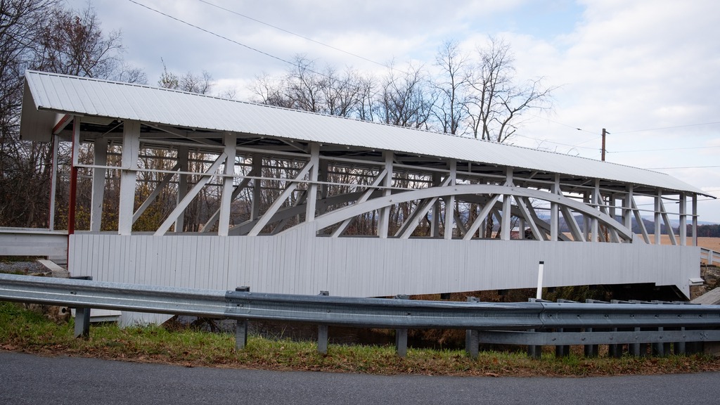
The Lower Humbert Covered Bridge, or the Faidley Covered Bridge, is an 126-foot-6-inch (38.56 m) Burr Arch truss covered bridge that crosses Laurel Hill Creek, in Lower Turkeyfoot Township. It was built in 1891 and was listed on the National Register of Historic Places on December 10, 1980. It has a more wooded setting in the base of a gorge.
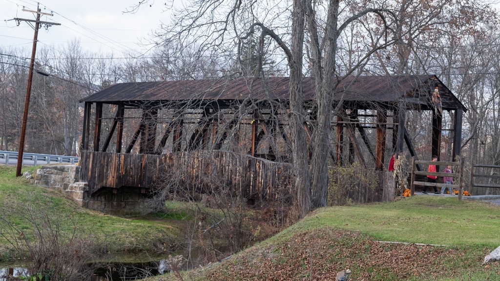
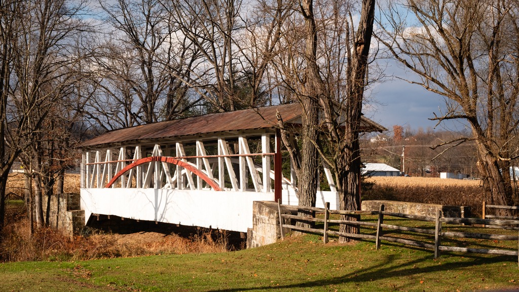
This post is a sampling of some of the sites of Somerset County. The first stop is the Somerset Historical Center and Walters Mill Covered Bridge. The Center is a 150-acre rural history museum with exhibits, workshops, and educational programs dedicated to preserving the history of life in southwestern Pennsylvania from the region’s first farmers to the present day. It also serves as headquarters of the Historical & Genealogical Society of Somerset County. The Visitors Center houses permanent and changing exhibits as well as the Genealogical Research Library. I found it to be a good general source of information about the area, which was a life saver when my phone decided not to cooperate with me.
The Walter’s Mill Covered bridge has been relocated to the property.
The covered bridge was built in 1859 and originally crossed Coxes Creek, four miles south of the town of Somerset. Major repairs were made to the bridge in 1909, at which time laminated wood arches were added to the bridge’s original multiple kingpost truss system to accommodate heavier vehicles. Overtaken by developments and threatened with destruction, the bridge was moved to the Somerset Historical Center in the early 1960s. Extensively restored in 1986, the bridge remains open to pedestrian traffic.
Nearby is the Quecreek Mine Rescue site. On July 24, 2002 coal miners at the Quecreek Mine in Lincoln Township, owned by Black Wolf Coal Company, accidentally dug into the abandoned, poorly documented Saxman Coal / Harrison #2 Mine, flooding the room and pillar mine with an estimated 75 million US gallons (280,000 cubic meters) of water. Both the Saxman Mine and Quecreek Mine are in the Upper Kittanning coal seam. Fortunately, all nine trapped miners were rescued using a metal capsule structure lowered into the mine through a drilled hole. The incident garnered national attention, especially in the wake of the September 11 disaster and the crash of Flight 93 nearby in Shanksville.
The nearby Dormel Farm.
Driving further north, one can visit the Trostletown Covered Bridge, a historic covered bridge in Quemahoning Township. It was built in 1845, and is a 104-foot-long (32 m) Kingpost truss bridge, with half-height plank siding and an asbestos shingled gable roof. The bridge crosses Stony Creek. It is one of 10 covered bridges in Somerset County. It was added to the National Register of Historic Places in 1980.
The bridge is adjacent to an American Legion Post with an impressive display of hardware.
Travelling from Bedford to Somerset, one encounters a string of covered bridges. First up is the Herline Covered Bridge, which is a wooden covered bridge which is located in Bedford County. It crosses the Juniata River, and is one of fifteen historic covered bridges which are located in Bedford County. Built in 1902, this historic structure is a 136-foot-long (41 m), Burr Truss bridge with a medium pitched gable roof. It was listed on the National Register of Historic Places in 1980.
Turners Covered Bridge is found off Route 31 in Bedford County. It is an 89 foot Burr Truss bridge, with low side panels and open sides. Construction date is believed to be approximately 1892. It spans the Raystown branch of the Juniata River. This half height style seems to have been popular in the area, as you will see in this post. The bridge is County owned and rests on stone abutments, reinforced with concrete.
I heard several killdeer calling from this field. They sounded like shorebirds, which makes sense since they are related to plovers.
The Colvin Covered Bridge has recently been refurbished. It is a multiple king-post bridge rather than the familiar Burr arch truss, resting on concrete abutments. Built in 1894, it crosses Shawnee Creek. The bridge is county owned and is 66 feet long. It was built in 1880.
Our trip now takes us into Somerset County. The New Baltimore Bridge is a covered bridge which crosses the Raystown Branch of the Juniata Rive. The Queen Post truss bridge was built in 1879 and is 86 feet 6 inches (26.37 m) in length and 12 feet (3.7 m) wide. It is one of 10 covered bridges in Somerset County.
I found these markers at covered bridges in Somerset County.
The Glessner Covered Bridge is a covered bridge in Somerset County near Shanksville. It was built in 1881, and is a 90-foot-long (27 m), multiple Kingpost truss bridge, with half-height plank siding and a tin covered gable roof. The bridge crosses Stonycreek River and is an interesting side trip if you are visiting the Flight 93 National Memorial. It was added to the National Register of Historic Places in 1980
The town of Bedford contains some interesting sights for the traveler. The Bedford Village Archeological Site is an archaeological site was once occupied by a Monongahela culture village. Today, the site is the location of Old Bedford Village, an open-air museum, containing a variety of historic structures transported to the site from the surrounding towns of Bedford, Everett, and Rainsburg.
Some of the structures at Old Bedford Village.It was a nice surprise to see this lovely horse and pony.
Adjacent to Old Bedford Village is the Claycomb Covered Bridge. It was was built in 1880 in Reynoldsdale and was moved to its present location in 1975. It is a burr truss design, 126 feet long, which has been reinforced with steel to support bus traffic that frequents Old Bedford Village. The structure is unpainted and the roof is constructed of Cedar shakes. The deck consists of crossboard planks and the sides are totally enclosed. It sits on poured concrete abutments.
Near the entrance to Old Bedford Village, I couldn’t resist a stop at the Penguin, which has a large menu of hard and soft ice cream and other treats.
Finally, one of Bedford’s iconic sites is the Coffee Pot.
Get ready – the upcoming posts contains a lot of covered bridges. We will also continue the two-per-week schedule of new posts.
I used the extended July Fourth holiday to take another trip to the Laurel Highlands. The trip started with an exit of the Pennsylvania Turnpike at Breezewood to see some covered bridges. The first stop of the trip was Jacksons Mill Covered Bridge, a wooden covered bridge located in Bedford County. It crosses Brush Creek and is a 91-foot-long (28 m), Burr Truss bridge, constructed in 1889. It is one of 15 historic covered bridges in Bedford County. The bridge was listed on the National Register of Historic Places in 1980.
There is also a very nice old mill building at this site.
Nearby is Feltons Mill Covered Bridge, which is another wooden covered bridge located in Bedford County. It is a 105-foot-long (32 m), Burr Truss bridge with a medium pitched gable roof, constructed in 1892. It also crosses Brush Creek. It was listed on the National Register of Historic Places in 1980.
I was not able to get a good photo of this bridge, as the entrance appears to be on private property. The access road had a rope across it and appears to terminate a short distance from the main road. The bridge might be viewable from the nearby main road bridge when the trees are not leafed out, However, this random haybale was sitting nearby, and you know I can’t resist a good haybale.
My drive around the Breezewood area also produced some other interesting sights, such as this interesting looking Church, with a very minimalist style.
More haybales of course.This old silo looked like a castle tower, if you squint.
Another covered bridge in a scenic area, the Sheard’s Mill Covered Bridge is located in East Rockhill Township and Haycock Township, Bucks County next to the Levi Sheard Mill. The bridge was built in 1873, and is 15-foot-wide (4.6 m) and 130-foot-long (40 m), making it one of Bucks County’s longest bridges. The bridge crosses the Tohickon Creek on Covered Bridge Road. The bridge was added to the National Register of Historic Places on December 1, 1980.
I don’t see a Burr Arch truss. It looks like another Lattice Truss, like South Perkasie.
The bridge is near the Levi Sheard Mill. It is also known as Sheard’s Mill and the John S. Clymer Mill, and is an historic, American grist mill that is located in East Rockhill Township, Bucks County. It was placed on the National Register of Historic Places on December 18, 2006. The first section of this historic structure was built circa 1825, with three additions built into the early twentieth century. The mill was purchased by Levi Sheard in 1844. In 1916, ownership was transferred to brothers Rubin and John Clymer. The mill continued to operate until the 1970s.
The South Perkasie Covered Bridge is a covered bridge that is located in Perkasie, Bucks County. It is the oldest covered bridge in Bucks County and was added to the National Register of Historic Places on December 1, 1980. Built in 1832, this bridge is a 93-foot-long (28 m), Town truss covered bridge that once crossed Pleasant Spring Creek, but was moved and rededicated on August 15, 1959 as a feature in Lenape Park. It is the third oldest Town Lattice bridge in the country. The bridge was heavily damaged by the remnants of Hurricane Ida in September 2021. As you can see below, it is currently closed for repairs.
South Perkasie is adjacent to the town of Sellersville which was founded in the early 18th century. It is centered on a major road known as Bethlehem Pike that connected Philadelphia to Bethlehem and the Lehigh Valley. The town was very small and was called Sellers Tavern. Its most notable feature was a large inn. The present Washington House in Sellersville, however, was not Sellers Tavern. When the railroad expanded to the area in 1856, Sellersville experienced a population increase. After the borough’s incorporation in 1874, there was even more growth in the area. Cigar, textile, and other industries established companies in Sellersville, including Schulmerich Bells (one of the world’s largest producers of electronic carillons and hand bells). Today Sellersville is largely a commuter town.
One of the best know institutions in town is the Sellersville Theater.
The Washington House Hotel and Restaurant on Main Street.The historic train station.
A short distance from the Chadds Ford area one enters the state of Delaware. Fred Smith’s Covered Bridge crosses the Brandywine Creek near the Brandywine tract of First State National Historic Park. It was reconstructed in 2002 after a fire in 1961. It is of the ever popular Burr Arch Truss design. The original Smith Bridge was built in 1839 and was a single span that crossed over Brandywine Creek, near Winterthur. It measured 154 feet long.
Heading south from Blue Knob, I visited several covered bridges in Bedford County. First up is the Osterburg Bowser Covered Bridge, a wooden covered bridge at East St. Clair Township. It is a 90-foot-long (27 m), Burr Truss bridge with a shallow gable roof. It crosses Bobs Creek, and it is one of 15 historic covered bridges in Bedford County. The bridge was listed on the National Register of Historic Places in 1980. It is an example of the bridges in this area that do not have complete sides.
The Osterburg Bowser Covered Bridge
I next made my way to Snooks Covered Bridge, a historic wooden covered bridge also located in East St. Clair Township Township. Built in 1883, it is a 75-foot-long (23 m), Burr Truss bridge with a shallow gable roof. It crosses Dunning Creek. It was listed on the National Register of Historic Places in (you guessed) 1980.
Snooks Covered Bridge
The Ryot Covered Bridge is wooden covered bridge that is located in West St. Clair Township. It was listed on the National Register of Historic Places in 1980. This bridge is a low to medium Burr Truss bridge with a shallow gable roof. It was damaged by fire in 2002, and reconstructed. The bridge was listed on the National Register of Historic Places in 1980.
A request to remove the bridge from the National Register was submitted after it was badly damaged by a fire in 2002. The bridge was set on fire by teenage arsonists in 2002. Most of the wooden parts of the bridge were badly damaged. The Ryot Bridge was rehabilitated only seven years earlier, so most of the added steel supports remained intact, along with the stone abutments. The bridge was restored by P. Joseph Lehman, Inc., at a total cost of $300,000.
The Ryot Covered Bridge
The Cuppett’s Covered Bridge, which was built by Cuppett brothers William & Philip on September 14, 1882, is a historic covered bridge that is located in Napier Township. Privately owned by the Cuppett family from the day it was built, the bridge took just five months to build for a total cost of $780. John Wayde did the masonry work, and Jeremiah Thompson completed the carpentry. Crossing Dunnings Creek, the 70-foot-long (21 m) bridge is a unique design with unusually low arches and low side walls which highlight the patented Burr Arch Truss system. The Cuppett’s Covered Bridge was listed on the U.S. National Register of Historic Places in 1980 by the United States Department of the Interior. The bridge was quite a popular spot for family photos when I was there.
The Cuppetts Covered Bridge, decorated for the season.
The Knisley Covered Bridge is a historic wooden covered bridge located at West St. Clair Township. It is an 80-foot-long (24 m), medium Burr Truss bridge with a shallow gable roof. It crosses Dunning Creek. The bridge was listed on the National Register of Historic Places in 1980.