• Allentown Area Covered Bridges

    I used my trip to the Poconos to stop and visit some historic covered bridges in the Allentown area.

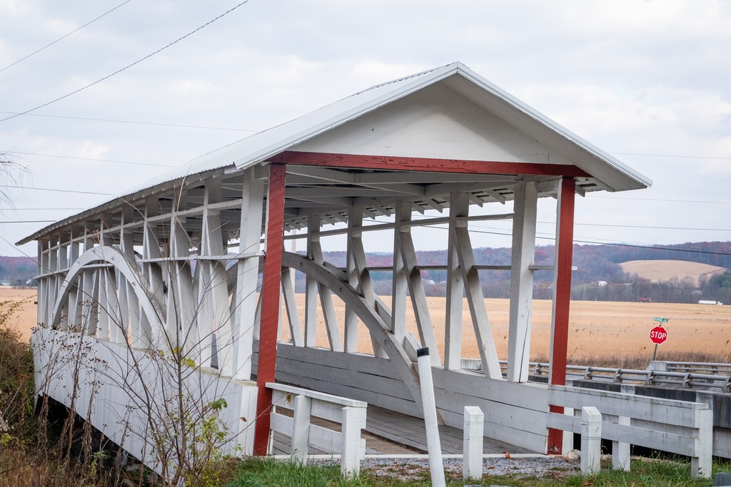
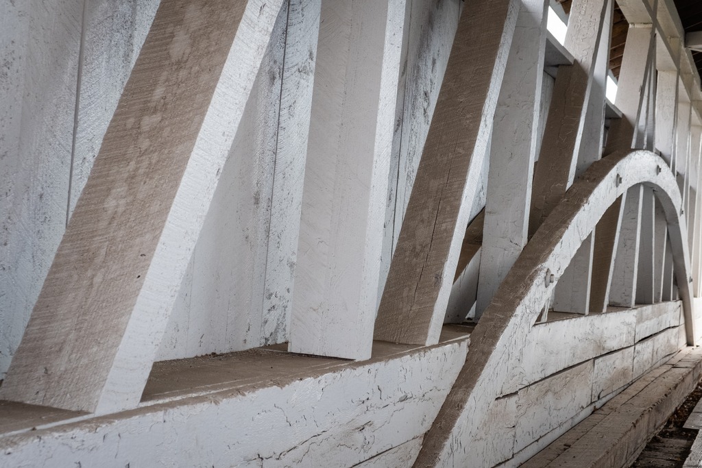
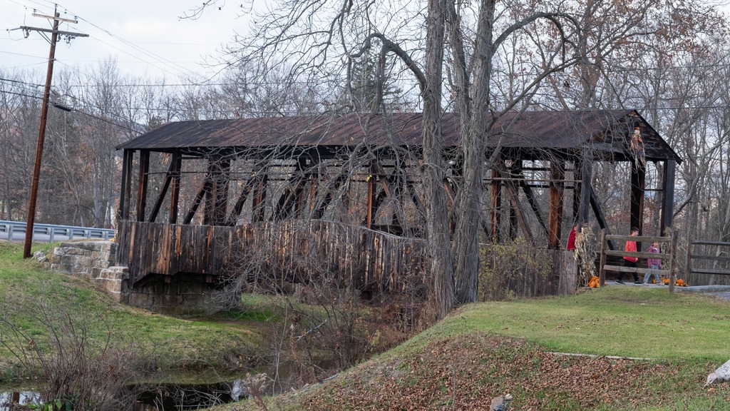
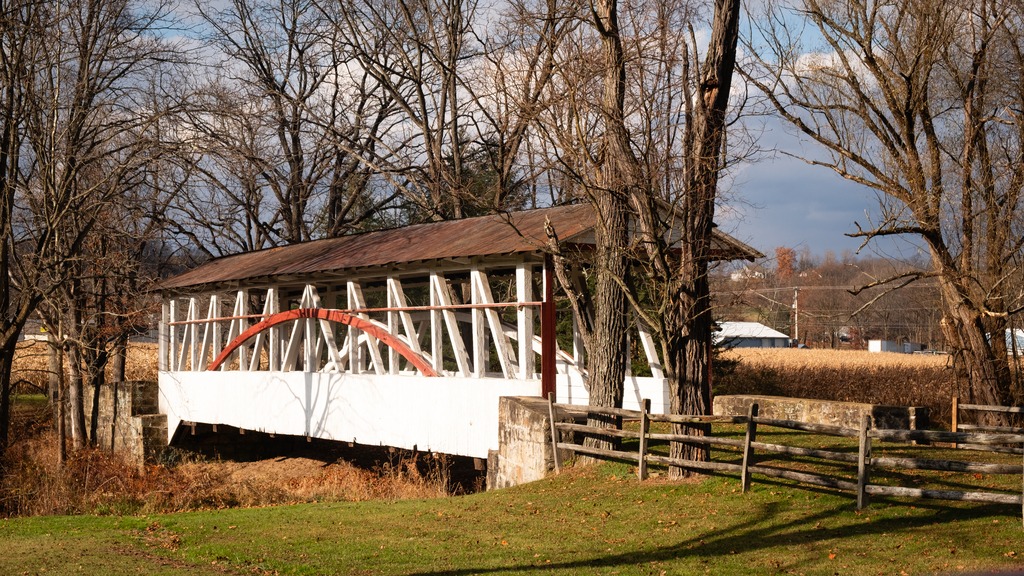
    My first stop was the Wehr Covered Bridge, a wooden covered bridge located in Lehigh County. It is a three span, 117-foot-long (36 m) Burr Truss bridge, constructed in 1841. It has horizontal siding and gable roof. It crosses Jordan Creek. It was listed on the National Register of Historic Places in 1980. There is and adjacent park, appropriately named Covered Bridge Park and a dam across Jordan Creek forming a small waterfall.

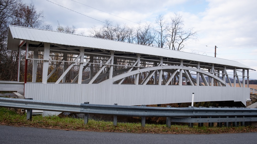
    Another interesting bridge with a nice setting is Manasses Guth Covered Bridge. It is a wooden covered bridge near the Wehr Covered Bridge. It is a 108-foot-long (33 m) Burr Truss bridge, constructed in 1858, and rebuilt in 1882. It has vertical siding. It also crosses Jordan Creek and was listed on the National Register of Historic Places in 1980. There is some interesting architecture near the bridge.

    The Geiger Covered Bridge is a is a 112-foot-long (34 m) Burr Truss bridge, constructed in 1860. It has vertical plank siding and an entry portal of stepped square planks. It also crosses Jordan Creek within the Trexler Nature Preserve. It was listed on the National Register of Historic Places in 1980.

    Finally, the Schlicher Covered Bridge is a wooden covered bridge that is 108-foot-long (33 m) Burr Truss bridge, constructed in 1882. It has vertical plank siding and a gable roof. It crosses Jordan Creek near the Lehigh Valley Zoo. It was listed on the National Register of Historic Places in 1980

  • More Somerset Covered Bridges

    Somerset County is one of the places in Pennsylvania that has done an excellent job of preserving its covered bridges. They make nice side trips if you are visiting for skiing or other outdoor activity, Driving south in the county, one comes to Barronvale Covered Bridge. This bridge, also known as Barron’s Mill Bridge, is a covered bridge in Middlecreek Township crossing Laurel Hill Creek. At 162 feet 3 inches (49.45 m) it is the longest remaining covered bridge in Somerset County. It is 13 feet 10 inches (4.22 m) wide. The Burr truss bridge was built in 1902 by Cassimer Cramer.

    The King’s Covered Bridge is in Middlecreek Township. It was built in 1802, and is a 127-foot-4-inch-long (38.81 m) Burr truss bridge, with an asbestos covered gable roof. The bridge also crosses Laurel Hill Creek and is easy to visit if you are also going to the Barronvale Bridge. It was added to the National Register of Historic Places in 1980. There is a nice picnic area adjacent to the bridge.

    The Lower Humbert Covered Bridge, or the Faidley Covered Bridge, is an 126-foot-6-inch (38.56 m) Burr Arch truss covered bridge that crosses Laurel Hill Creek, in Lower Turkeyfoot Township. It was built in 1891 and was listed on the National Register of Historic Places on December 10, 1980. It has a more wooded setting in the base of a gorge.

  • Vosburg Neck – The Most Compelling New State Park

    Vosburg Neck State Park lies five miles west of Tunkhannock in Wyoming County. The park’s 669 acres feature historic buildings from the 1700 and 1800s, a canal bed and rail bed,, and a 1700s-era cemetery. Recreational activities include eight miles of trails, non-motorized boating access, and picnic areas.

    The park is one of Pennsylvania’s three new state parks, and the most developed to date. The park was formerly the Howland Preserve. It is located in an oxbow on the north branch of the Susquehanna River known as the Vosburg Neck and features a diverse range of habitat.

    The park office.
    The Riverside Barn seemed to have been in use for a private function before I arrived.
    Private residences dot the area. I also lust after one of these trailers
    The boat launch.
    A lovely private home.
    The cemetery.
  • Color is Budding Out All Over

    Lancaster County on a lovely Spring day provides beautiful views of flowers and flowering trees. The tree buds in the local woodlands also create more color than one might expect.

    The local farms are also getting into the swing of things for the upcoming growing season.

  • Hibernia – There and Back, Part I

    On my way to visit Hibernia County Park in Chester County, I was finally able to photograph this barn and the adjacent house near Coatesville that I had long wanted to get a picture of.

    I also finally made a trip to the Coatesville Reservoir, another place I had never visited before.

    Here are some other interesting sights in the area of Wagontown, Chester County.

  • Late Winter Sets the Scene for Spring

    It now feels more like Spring in Chester County, although the calendar still says it’s Winter. The weather, however, can’t seem to make up its mind. We start with a few scenes around Kimberton.

    French Creek
    Further east, I’m not sure what these critters are. They may be llamas or alpacas.
    I loved the golden hour glow on this house.
    At this house, it is apparently still Christmas.
  • Bedford County Beauties

    Heading south from Blue Knob, I visited several covered bridges in Bedford County. First up is the Osterburg Bowser Covered Bridge, a wooden covered bridge at East St. Clair Township. It is a 90-foot-long (27 m), Burr Truss bridge with a shallow gable roof. It crosses Bobs Creek, and it is one of 15 historic covered bridges in Bedford County. The bridge was listed on the National Register of Historic Places in 1980. It is an example of the bridges in this area that do not have complete sides.

    The Osterburg Bowser Covered Bridge

    I next made my way to Snooks Covered Bridge, a historic wooden covered bridge also located in East St. Clair Township Township. Built in 1883, it is a 75-foot-long (23 m), Burr Truss bridge with a shallow gable roof. It crosses Dunning Creek. It was listed on the National Register of Historic Places in (you guessed) 1980.

    Snooks Covered Bridge

    The Ryot Covered Bridge is wooden covered bridge that is located in West St. Clair Township. It was listed on the National Register of Historic Places in 1980. This bridge is a low to medium Burr Truss bridge with a shallow gable roof. It was damaged by fire in 2002, and reconstructed. The bridge was listed on the National Register of Historic Places in 1980.

    A request to remove the bridge from the National Register was submitted after it was badly damaged by a fire in 2002. The bridge was set on fire by teenage arsonists in 2002. Most of the wooden parts of the bridge were badly damaged. The Ryot Bridge was rehabilitated only seven years earlier, so most of the added steel supports remained intact, along with the stone abutments. The bridge was restored by P. Joseph Lehman, Inc., at a total cost of $300,000.

    The Ryot Covered Bridge

    The Cuppett’s Covered Bridge, which was built by Cuppett brothers William & Philip on September 14, 1882, is a historic covered bridge that is located in Napier Township. Privately owned by the Cuppett family from the day it was built, the bridge took just five months to build for a total cost of $780. John Wayde did the masonry work, and Jeremiah Thompson completed the carpentry. Crossing Dunnings Creek, the 70-foot-long (21 m) bridge is a unique design with unusually low arches and low side walls which highlight the patented Burr Arch Truss system. The Cuppett’s Covered Bridge was listed on the U.S. National Register of Historic Places in 1980 by the United States Department of the Interior. The bridge was quite a popular spot for family photos when I was there.

    The Cuppetts Covered Bridge, decorated for the season.

    The Knisley Covered Bridge is a historic wooden covered bridge located at West St. Clair Township. It is an 80-foot-long (24 m), medium Burr Truss bridge with a shallow gable roof. It crosses Dunning Creek. The bridge was listed on the National Register of Historic Places in 1980.

    The Knisely Covered Bridge
  • Looking Back at Autumn

    Autumn is my favorite time of year and probably the most photogenic time in Pennsylvania. Here is a look back at some fall foliage in northwestern Chester County.

  • Let’s Enjoy Some Fall Foliage and a Woodland Drive

    Here are some photos of a recent trip to State Game Lands 110 and 211. SGL 110 is northwest of Hamburg. This game land runs along the top of a ridgeline on Blue Mountain. The Appalachian Trail also travels through this area. The leaves were starting to change color when I was there:

    I next travelled into Dauphin and Lebanon Counties to visit State Game Land 211, the home of the Stony Valley trail, a former railroad bed belonging to the Dauphin and Susquehanna Railroad. This area was formerly the site of small towns supported by mining, timbering, ice harvesting and spring water bottling. The eastern end of the trail runs along side a well-known beaver pond.

  • Finishing With Something I Didn’t Expect

    Mount Davis (3,213 ft or 979 m) is the highest point in Pennsylvania. Located in the 5,685-acre (2,301 ha) Forbes State Forest near the hamlet of Markleton in Elk Lick Township, Somerset County, it lies on a gentle crest of a 30-mile (50 km) ridge line extending from central Somerset County southward into Garrett County, Maryland. The high point was named for John Nelson Davis, an early settler, American Civil War veteran, surveyor, and naturalist known for his studies of the mountain’s flora and fauna. During the Civil War, Davis served in Company E, 102nd Pennsylvania Infantry.

    The summit of Mt. Davis may be ascended by car or a number of hiking trails. Its surroundings are noted for their patterns of unusual circular stone formed by periglacial action. A metal observation tower with a relief map of the region stands near the true high point.

    I found this location surprising. It was not what I was picturing in my mind for many years. The area immediately surrounding the summit is state forest, however you can be a five minute drive from the summit and still be going through farmland, which doesn’t make the peak seem that prominent or that high. I guess the surrounding area is at a pretty high elevation.

    Mt. Davis lake from the summit.
    This is actually the best view, rather than the fire tower.
    This state forest facility is near the remnants of an old CCC camp.
    Looks like an old CCC cabin.
    This young man waved hello as he passed. I found quite a few Amish farms in the area.
error: Content is protected !!