Here is a look around the area near my aunt’s farm in Greenwood Township, Columbia County from the opening weekend of rifle deer season. Sadly, no one had any luck that weekend.


Here is a look around the area near my aunt’s farm in Greenwood Township, Columbia County from the opening weekend of rifle deer season. Sadly, no one had any luck that weekend.
A drive through Berks and Schuylkill Counties this past Autumn provided some scenic views. First up is the Zimmerman Covered Bridge in Schuylkill County. Originally built in 1880, it is 65 feet long.


The Dreibelbis Station Bridge is a 172 foot long Burr arch truss covered bridge spanning Maiden Creek south of Lenhartsville, Berks County. The bridge was built in 1869 and was added to the National Register of Historic Places on February 23, 1981. Another Berks bridge with a hex sign – I love it.


Kutz’s Mill Bridge is a historic wooden covered bridge located at Greenwich Township in Berks County, Pennsylvania. It is a 93 foot long, Burr Truss bridge, constructed in 1854. It crosses the Sacony Creek. As the name implies, it leads to the Kutz Mill. It was listed on the National Register of Historic Places in 1981.


The Rock Covered Bridge is a single-span Burr arch truss 55 feet 7 inches over Little Swatara Creek in Schuylkill County.


Shikellamy State Park is an unusual park in that it contains two distinctly different sections. It also affords great views of the two branches of the Susquehanna River (the West Branch and the North Branch ). The Park is in both Union and Northumberland counties. The 54-acre Shikellamy Marina is on the southern tip of Packers Island at the confluence of the West Branch and North Branch Susquehanna River, and offers hiking and biking trails, a marina, and boat launch. The 78-acre Shikellamy Overlook is on the western shore of the Susquehanna River. A 360-foot cliff overlooks the confluence of the two branches of the river.
Although the marina area seemed more popular with Labor Day party goers, I was more impressed with the views on the overlook side.


The Marina Section provides great access to the water as well as picnicking opportunities.


Heading south from Tioga County to find a couple of the more urban state parks, I first went in search of a covered bridge in Lycoming County that I had missed on a previous trip. This bridge was on private property, so only a distant shot was possible. The James S. Fink covered bridge was built in 1986 utilizing a Stringer truss design. It crosses Larry’s creek in Anthony Township. The structure is 62 feet long and is open to vehicle traffic, but it is on a private road.

Susquehanna State Park is a 20-acre riverfront recreational area is in the city of Williamsport. The Williamsport Chamber of Commerce operates this park in cooperation with the state. It is primarily a location for river access for boating and fishing. There are also opportunities for picnicking, wildlife watching, and gongoozling (google it). It is next to the boarding point for the riverboat Hiawatha.


Milton State Park is an 82-acre island on the West Branch Susquehanna River, between the boroughs of Milton and West Milton. The northern half of the park has day use facilities and the southern half remains in a wooded state for hiking and nature study. It also has a boat launch, playground and extensive soccer fields.


This post features a quick series of covered bridges in northwestern Lancaster County, the home of the largest number of covered bridges in the state. The first up is Schenk’s Mill Covered Bridge (or Shenk’s Mill Covered Bridge). It is a covered bridge that spans Big Chiques Creek. The bridge has a single span, wooden, double Burr arch truss design with the addition of steel hanger rods. The deck is made from oak planks. It is painted red and both approaches to the bridge are painted white. It is one of only 3 covered bridges in the county with horizontal side boards. It is listed on the National Register of Historic Places. The bridge was built in 1847 by Charles Malhorn and Levi Fink. It was rebuilt in 1855 and is 80 feet long.

The Shearer’s Covered Bridge is a covered bridge that also spans Big Chiques Creek. The bridge has a single span, wooden, double Burr arch truss design. It is the only covered bridge in the county painted entirely in red in Lancaster County, on both the inside and outside, including both approaches. The other all red bridge, Pool Forge Covered Bridge, is only painted on the outside. It is one of only 3 covered bridges in the county with horizontal side boards. It is listed on the National Register of Historic Places. The bridge was built in 1847 by Jacob Clare. It was rebuilt in 1855 and stayed its original location until it was moved in 1971 to its present location in the Manheim Memorial Park. It is 86 feet long.


The Pinetown Bushong’s Mill Covered Bridge is a covered bridge that spans the Conestoga River. The bridge is also known as the Pinetown Amish Covered Bridge, Pinetown Covered Bridge, Nolte’s Point Mill Bridge and Bushong’s Mill Bridge.
The bridge has a single span, wooden, double Burr arch truss design with the addition of steel hanger rods. The deck is made from oak planks. It is listed on the National Register of Historic Places. The bridge was built in 1867 by Elias McMellen at a cost of $4,500. In 1972, it was destroyed as a result of flooding caused by Hurricane Agnes. Due to a tremendous response of area residents who signed a petition for its reconstruction, it was among the first covered bridges to be restored after Agnes. In the spring of 1973, the bridge was rebuilt by the nearby Amish. To prevent damage due to future flooding, they raised the bridge to 17 feet 6 inches above the average water line. Lititz Run joins the Conestoga River at this site. It is 124 feet long.

The Kauffman’s Distillery Covered Bridge, or Sporting Hill Bridge, is a covered bridge that spans Chiques Creek. The bridge has a single span, wooden, double Burr arch truss design with the addition of steel hanger rods. The deck is made from oak planks.
It is registered on the National Register of Historic Places. Kauffman’s Distillery Covered Bridge was originally built in 1857 at a cost of $1,185 by James C. Carpenter. The bridge was named after the Kauffman’s Distillery Mill which operated in the late 1800s. In 1874, the bridge was rebuilt by Elias McMellen at a cost of $1,620. It is 84 feet long.

Hunsecker’s Mill Covered Bridge is a covered bridge located in Lancaster County, Pennsylvania, United States. The bridge has a single span, wooden, double Burr arch truss design. The bridge, which spans the Conestoga River, is 180 feet long, making it the longest single span covered bridge in the county. The original bridge was built in 1843 by John Russell at a cost of $1,988. It is a double Burr Arch truss system. It has been swept away in flooding numerous times, most recently in 1972 after Hurricane Agnes. Waters lifted the original structure off its abutments and carried it downstream. In 1973, following destruction from the hurricane, it was rebuilt at a cost of $321,302. While Schenck’s covered bridge is one of 3 bridges with horizontal siding boards, the Hunsecker’s Mill bridge may be the only one in Lancaster County with horizontal floor boards which give a unique vibration upon crossing. A detailed scale model (~7′ long), complete with stone abutments, was donated to the Lancaster Mennonite Historical Society and may be available for viewing.

Erb’s Mill Covered Bridge is a covered bridge that spans Hammer Creek. The bridge has a single span, wooden, double Burr arch truss design with the addition of steel hanger rods. The deck is made from oak planks. It was added to the National Register of Historic Places in 1980. The bridge was originally built in 1849 for a cost of $700. It was built on the Erb family’s tract of land in the farming region along Hammer Creek. In 1887 the bridge was rebuilt by John G. Bowman for $1744. It is 70 feet long.

The Bucher’s Mill Covered Bridge (or Butcher’s Mill Covered Bridge) is a covered bridge that spans Cocalico Creek. After the Landis Mill Covered Bridge, it is the second shortest covered bridge in the county. The bridge has a single span, wooden, double Burr arch truss design with the addition of steel hanger rods. The deck is made from oak planks.
It is registered on the National Register of Historic Places. Bucher’s Mill Covered Bridge was built in 1891 by Elias McMellen, using single span, wooden, double Burr arch truss construction, at a cost of $1167. A year later, in 1892, the bridge was damaged heavily in a flood and was rebuilt by McMellen for $1025. At only 64 feet long, it is one of the shortest covered bridges in Lancaster County.

In 1996, Charlestown Township in Chester County purchased 20 acres of the Brightside Farm located to preserve it from impending development. The Township added 55 additional acres to Brightside Farm Park with the purchase of the rest of the farm with the help of a significant grant from Chester County in the year 2000. The farm is preserved as an agricultural asset for the residents to enjoy, and a portion of the property is under a conservation easement with the French & Pickering Creeks Trust. The park offers over 50 garden plots to township residents and has walking trails.


A feature in the Park is the Wisner Rapp House. Jacob Wisner House, also known as the Rapp House, is a historic home that was built in two sections. The older section dates to 1761, and is a 2 1/1-story, three bay wide, stone structure. A two bay wide extension was added in the 1840s. The addition was originally built to house a saddle and harness-maker’s shop and later housed the Sidley Post Office.

Finally, a look around the neighboring area …


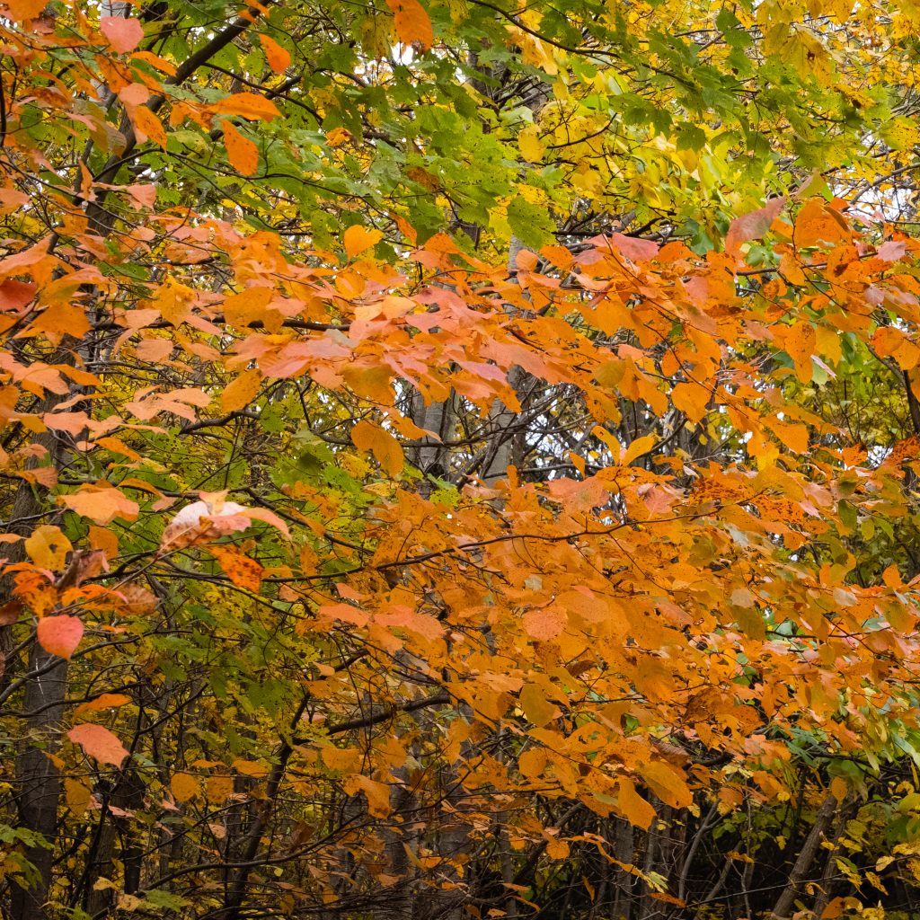
This Autumn I had an opportunity to take a drive through State Games Lands 110 in Berks and Schuylkill Counties. The auto tour provides an opportunity to explore roads not usually open to traffic along the top of the Blue Mountain ridge.
Deer, bear and turkeys are some of the wildlife you’ll find in Game Lands 110, a 10,310-acre forested area along Blue Mountain. The Appalachian Trail is located on the top of the Blue Mountain and runs the length of the game lands from Route 183 to Port Clinton. The area does provide some beautiful fall color. After a short but steep drive up the mountain, the route continued along a relatively flat road along the crest from east to west. Here are some of my shots from along the route:


This is a weekend to remember all our blessings – the people, places and things that make life worthwhile. I am grateful that this Commonwealth has such and abundance of natural beauty and wonderful people,
Here are some scenes from lovely Tioga County from this past summer. Next week we will be taking a break from northcentral Pennsylvania for a series of locations that a bit farther afield.


There are some fantastic locations in Pennsylvania that have escaped my notice, even after all these years. Perhaps, in the case of our next location, it is because it’s almost all the way to the New York State line.
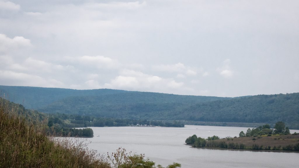
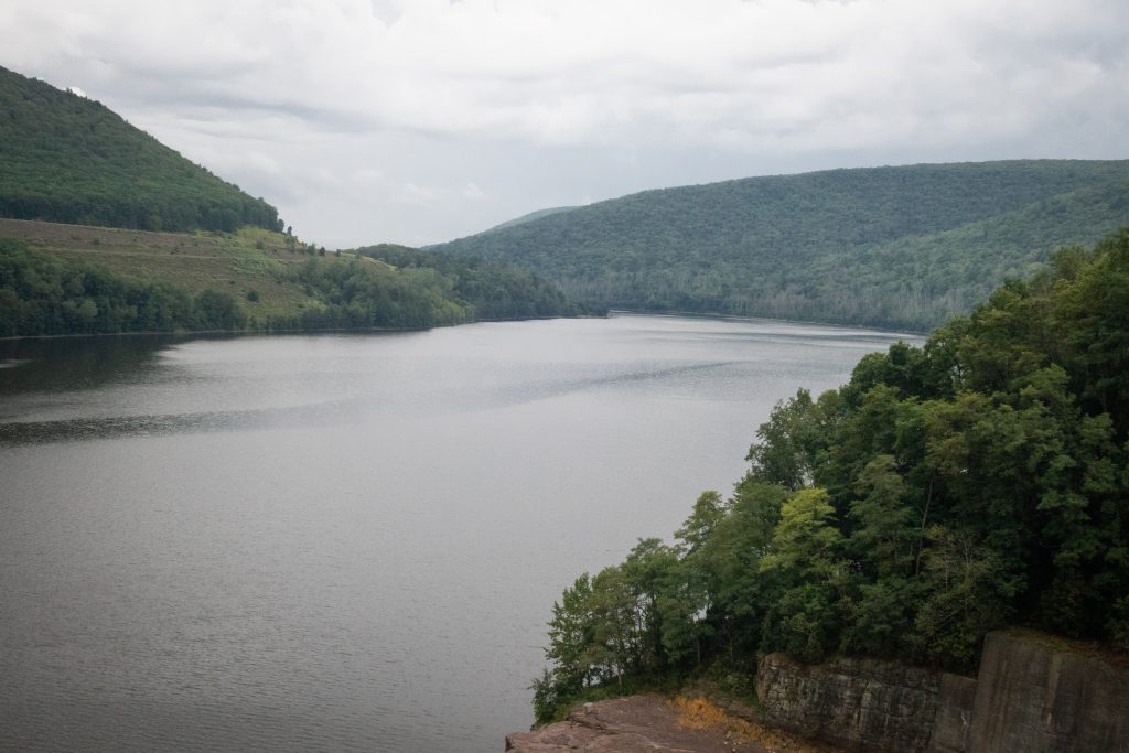
Tioga-Hammond Lakes are twin lakes in north central Pennsylvania with overnight and day use facilities in a scenic environment, southwest of Tioga, PA and north of Wellsboro on PA on Route 287. The recreation area has camping, a swimming beach, sand volleyball court, playground, boat launches, field sports area, a camp store, trails hunting, display gardens, archery trail, scenic overlooks and picnic facilities including grills and picnic shelters. There area is administered by the US Army Corps of Engineers.
The lakes were formed by the building of two separate dams, one on the Tioga River and one on Crooked Creek. They are connected by a channel cut through the rock which has its own weir on the Tioga Reservoir side. This unusual arrangements allows acid polluted water to mix with cleaner water from the other stream, increasing overall water quality downstream.