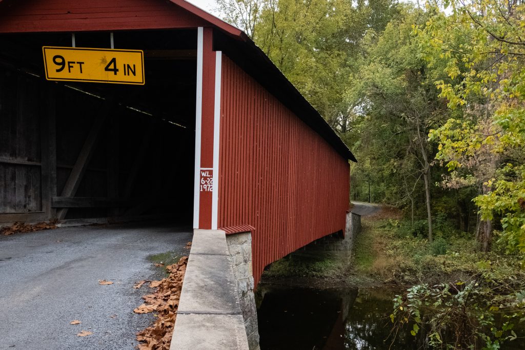
A drive through Berks and Schuylkill Counties this past Autumn provided some scenic views. First up is the Zimmerman Covered Bridge in Schuylkill County. Originally built in 1880, it is 65 feet long.
Zimmerman Covered BridgeThe familiar Burr Arch Truss construction.A neat old shed.Are you looking at us?These cows do not seem to care.
The Dreibelbis Station Bridge is a 172 foot long Burr arch truss covered bridge spanning Maiden Creek south of Lenhartsville, Berks County. The bridge was built in 1869 and was added to the National Register of Historic Places on February 23, 1981. Another Berks bridge with a hex sign – I love it.
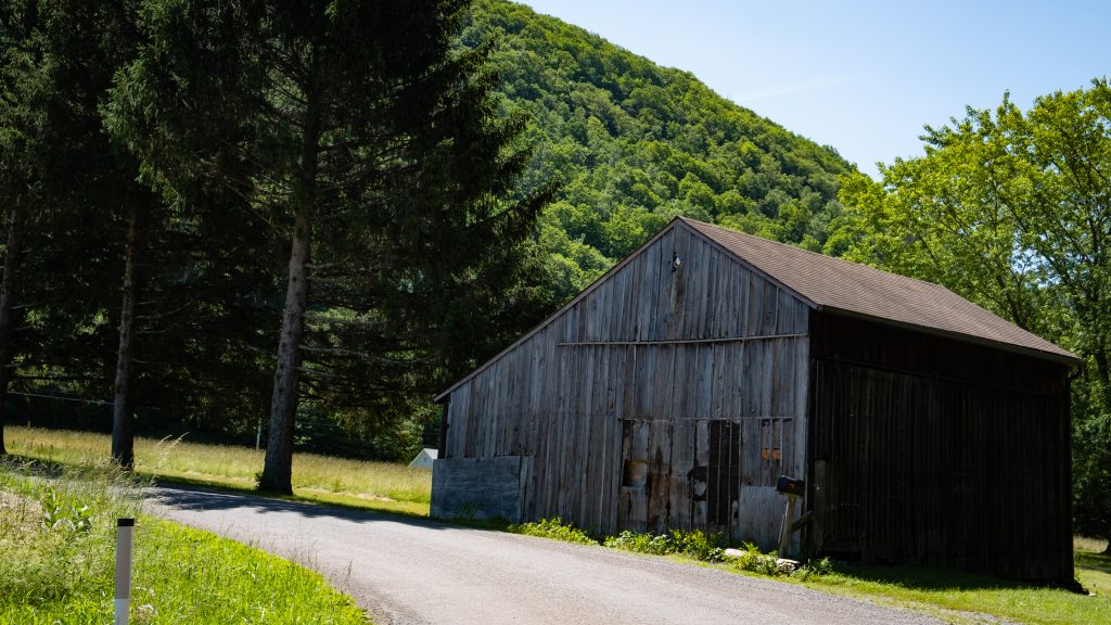
A pretty farm property
Kutz’s Mill Bridge is a historic wooden covered bridge located at Greenwich Township in Berks County, Pennsylvania. It is a 93 foot long, Burr Truss bridge, constructed in 1854. It crosses the Sacony Creek. As the name implies, it leads to the Kutz Mill. It was listed on the National Register of Historic Places in 1981.
Kutz’s Mill Covered BridgeKutz’s Mill
The Rock Covered Bridge is a single-span Burr arch truss 55 feet 7 inches over Little Swatara Creek in Schuylkill County.
Heading south from Tioga County to find a couple of the more urban state parks, I first went in search of a covered bridge in Lycoming County that I had missed on a previous trip. This bridge was on private property, so only a distant shot was possible. The James S. Fink covered bridge was built in 1986 utilizing a Stringer truss design. It crosses Larry’s creek in Anthony Township. The structure is 62 feet long and is open to vehicle traffic, but it is on a private road.
Susquehanna State Park is a 20-acre riverfront recreational area is in the city of Williamsport. The Williamsport Chamber of Commerce operates this park in cooperation with the state. It is primarily a location for river access for boating and fishing. There are also opportunities for picnicking, wildlife watching, and gongoozling (google it). It is next to the boarding point for the riverboat Hiawatha.
Labor Day chill by the river.The boat rampThe Lance Corporal Abram Howard Memorial Bridge
Milton State Park is an 82-acre island on the West Branch Susquehanna River, between the boroughs of Milton and West Milton. The northern half of the park has day use facilities and the southern half remains in a wooded state for hiking and nature study. It also has a boat launch, playground and extensive soccer fields.
This post features a quick series of covered bridges in northwestern Lancaster County, the home of the largest number of covered bridges in the state. The first up is Schenk’s Mill Covered Bridge (or Shenk’s Mill Covered Bridge). It is a covered bridge that spans Big Chiques Creek. The bridge has a single span, wooden, double Burr arch truss design with the addition of steel hanger rods. The deck is made from oak planks. It is painted red and both approaches to the bridge are painted white. It is one of only 3 covered bridges in the county with horizontal side boards. It is listed on the National Register of Historic Places. The bridge was built in 1847 by Charles Malhorn and Levi Fink. It was rebuilt in 1855 and is 80 feet long.
Shenk’s Mill Covered Bridge
The Shearer’s Covered Bridge is a covered bridge that also spans Big Chiques Creek. The bridge has a single span, wooden, double Burr arch truss design. It is the only covered bridge in the county painted entirely in red in Lancaster County, on both the inside and outside, including both approaches. The other all red bridge, Pool Forge Covered Bridge, is only painted on the outside. It is one of only 3 covered bridges in the county with horizontal side boards. It is listed on the National Register of Historic Places. The bridge was built in 1847 by Jacob Clare. It was rebuilt in 1855 and stayed its original location until it was moved in 1971 to its present location in the Manheim Memorial Park. It is 86 feet long.
Shearer’s Mill Covered Bridge
The Pinetown Bushong’s Mill Covered Bridge is a covered bridge that spans the Conestoga River. The bridge is also known as the Pinetown Amish Covered Bridge, Pinetown Covered Bridge, Nolte’s Point Mill Bridge and Bushong’s Mill Bridge.
The bridge has a single span, wooden, double Burr arch truss design with the addition of steel hanger rods. The deck is made from oak planks. It is listed on the National Register of Historic Places. The bridge was built in 1867 by Elias McMellen at a cost of $4,500. In 1972, it was destroyed as a result of flooding caused by Hurricane Agnes. Due to a tremendous response of area residents who signed a petition for its reconstruction, it was among the first covered bridges to be restored after Agnes. In the spring of 1973, the bridge was rebuilt by the nearby Amish. To prevent damage due to future flooding, they raised the bridge to 17 feet 6 inches above the average water line. Lititz Run joins the Conestoga River at this site. It is 124 feet long.
Pinetown Amish Covered Bridge
The Kauffman’s Distillery Covered Bridge, or Sporting Hill Bridge, is a covered bridge that spans Chiques Creek. The bridge has a single span, wooden, double Burr arch truss design with the addition of steel hanger rods. The deck is made from oak planks.
It is registered on the National Register of Historic Places. Kauffman’s Distillery Covered Bridge was originally built in 1857 at a cost of $1,185 by James C. Carpenter. The bridge was named after the Kauffman’s Distillery Mill which operated in the late 1800s. In 1874, the bridge was rebuilt by Elias McMellen at a cost of $1,620. It is 84 feet long.
Kauffman’s Distillery Covered Bridge
Hunsecker’s Mill Covered Bridge is a covered bridge located in Lancaster County, Pennsylvania, United States. The bridge has a single span, wooden, double Burr arch truss design. The bridge, which spans the Conestoga River, is 180 feet long, making it the longest single span covered bridge in the county. The original bridge was built in 1843 by John Russell at a cost of $1,988. It is a double Burr Arch truss system. It has been swept away in flooding numerous times, most recently in 1972 after Hurricane Agnes. Waters lifted the original structure off its abutments and carried it downstream. In 1973, following destruction from the hurricane, it was rebuilt at a cost of $321,302. While Schenck’s covered bridge is one of 3 bridges with horizontal siding boards, the Hunsecker’s Mill bridge may be the only one in Lancaster County with horizontal floor boards which give a unique vibration upon crossing. A detailed scale model (~7′ long), complete with stone abutments, was donated to the Lancaster Mennonite Historical Society and may be available for viewing.
Hunsecker’s Mill Covered Bridge
Erb’s Mill Covered Bridge is a covered bridge that spans Hammer Creek. The bridge has a single span, wooden, double Burr arch truss design with the addition of steel hanger rods. The deck is made from oak planks. It was added to the National Register of Historic Places in 1980. The bridge was originally built in 1849 for a cost of $700. It was built on the Erb family’s tract of land in the farming region along Hammer Creek. In 1887 the bridge was rebuilt by John G. Bowman for $1744. It is 70 feet long.
Erb’s Mill Covered Bridge
The Bucher’s Mill Covered Bridge (or Butcher’s Mill Covered Bridge) is a covered bridge that spans Cocalico Creek. After the Landis Mill Covered Bridge, it is the second shortest covered bridge in the county. The bridge has a single span, wooden, double Burr arch truss design with the addition of steel hanger rods. The deck is made from oak planks.
It is registered on the National Register of Historic Places. Bucher’s Mill Covered Bridge was built in 1891 by Elias McMellen, using single span, wooden, double Burr arch truss construction, at a cost of $1167. A year later, in 1892, the bridge was damaged heavily in a flood and was rebuilt by McMellen for $1025. At only 64 feet long, it is one of the shortest covered bridges in Lancaster County.
Knapp’s Covered Bridge is a Burr arch truss covered bridge over Brown’s Creek in Burlington Township, Bradford County. It was built in 1853 and is 95 feet (29.0 m) long. The bridge was placed on the National Register of Historic Places in 1980 and had a major restoration starting in 2000. Knapp’s Bridge is named for a local family, and is also known by as the Luther’s Mills Covered Bridge (for the nearby village of Luther’s Mills) and as the Brown’s Creek Covered Bridge.
The surrounding countryside also provides some nice sightseeing, like this pretty church with its barn across the road and the nearby farmland.
Berks County is the home to a few covered bridges and some very picturesque spots. Greisemer Covered Bridge is one of few I have seen with a hex sign. The oak design is one of my favorite hex signs. Here are a few views of the bridge. You will note the common Burr arch truss design.
A lovely church property stands between the two bridges featured in this blog. This is Salem United Church of Christ in Oley and its churchyard. The view toward the hills beyond is really lovely.
A nice view with the farm in back. These cows were across the road from the church.The Pleasantville Covered Bridge
The Pleasantville Covered Bridge is on more busy stretch of the appropriately named Covered Bridge Road and more difficult to photograph. As a white bridge, it provides a nice contrast with the red Greisemer Bridge. It is interesting that, although I see barn stars everywhere, I tend to see hex signs more often in Berks County.
Headed home, I came across this fantastic barn with hex signs.Looks like soybean at this farm.
Lycoming County has a total of four covered bridges. I visited two of them on my way home from Potter County.
The Buttonwood Bridge (also known as the Blockhouse Bridge) was built in 1898 with the structure spanning Blockhouse Creek. It uses a queen post with king post truss and is 74 feet 2 inches (22.6 m) long. The bridge is in good condition with a new wood shingled roof and pressure treated floor. The structure is open to traffic all year long. The bridge was placed on the National Register of Historic Places in 1980 and had a major restoration in 1998. It is the shortest and most heavily used of the three covered bridges remaining in Lycoming County.
A couple of looks inside the bridge.An interesting sawmill operation near the bridge.Very nice looking barn.Anther pretty barn shot.
The next bridge to the south was the Cogan House Bridge. This bridge was built in 1877 of the Burr Arch design with a structure length of 94 feet crossing Larry’s Creek. Cogan House bridge is open to traffic, and leads to a dead end private drive near the game lands. The bridge was placed on the National Register of Historic Places in 1980, and had a major restoration in 1998. The Cogan House bridge is named for the township and village of Cogan House, and is also known by at least four other names: Buckhorn, Larrys Creek, Day’s, and Plankenhorn.
The Cogan House Covered Bridge was constructed by a millwright who assembled the timber framework in a field next to the sawmill, before it was reassembled at the bridge site. It was the only bridge on Larrys Creek that survived the flood of June 1889, and one of only a handful that were left intact in the county. Although the bridge used to carry a steady flow of tannery and sawmill traffic, the clearcutting of the surrounding forests meant the end of those industries by the early 20th century.
The route to the bridge.The other side.A look inside.Cattle on a hill en route to the bridge.
Nestled in southwest Chester County near the Maryland line are several patches of a unique ecosystem called serpentine barrens. One example is found at Nottingham County Park. Dedicated in September 1963, Nottingham Park was the first Chester County park. The 731-acre park sits atop an outcropping of serpentine stone greater than one square mile in size – one of the largest serpentine barrens on the East Coast. It features former feldspar and serpentine quarries, and numerous former chromite ore mines. The National Park Service recognized Nottingham Park as a National Natural Landmark in 2008.
Nottingham Park offers nine pavilions, an 18-station fitness trail, and three modern, handicapped accessible playgrounds. To experience the serpentine barrens, one must wander around some of the trails in the park.
Serpentine, a geological outcrop of rare, light-green rock found only in three small geographic areas in all of North America, has soil so low in essential nutrients and so high in some metals that most ordinary plants will not grow. The barrens have their own community of plants, some of them globally-rare, with practically no species in common with the surrounding forests and fields. Typically, serpentine barrens contain scrub oak, pine, cedar and unique wildflowers. Some areas dominated by grasses are known as true prairies. Some areas with scattered trees are known as a savannah, which can survive and prosper with occasional fires.
Here are some views looking towards the serpentine barrens.Adorable mini covered bridge next to a pond.
The presence of a snowy owl in the area causes great excitement. Even the local news take notice. A bird in eastern Lancaster County recently created the expected onslaught of birders. I set out one Saturday to have a look as well. Note to self: don’t go looking for an owl without your “good” camera.
The bird was close to the road but not in front of the most photogenic backdrop. The online consensus is that it is a “she,” but I’m not sure how you tell juveniles from females.
On a porch roof.Grainy close up courtesy of phone camera.Is the bird thinking “There are so many, but are they edible?”One of the benefits of an owl on your porch roof is that everyone can see your laundry drying.The farm across the road.The area is full of lovely farms.The hay obsession continues. This is quite a pile.Horses had clearly been using this hitching post at Hayloft Ice Cream.The Willows Covered Bridge along busy Route 30. Probably one of the saddest covered bridges in the state.
Adams County is home to four covered bridges. A visit to the bridges provides a focus for a drive outside Gettysburg for visitors to the area. As usual, covered bridges look best to me in Autumn.
The first up the Anderson Farm Covered Bridge. The builder of this bridge is unknown, the length is 79 ft., and the width is 14 ft. The bridge appears to be in very good shape and closed to all traffic. The bridge is used for storage by the present owners of the property This structure originally spanned Mud creek. It was moved to the point where it is today by a farmer named Anderson.
Heikes Covered Bridge is located approximately 2.5 miles north of Heidlersburg, between Tyrone and Huntington Township. The structure was built in 1892 and uses the Burr truss, and the builder is unknown. The bridge crosses Bermudian Creek and is 67 ft. long and 14 ft. wide. The bridge is not open to any traffic and is located on private land.
Jack’s Mountain Bridge is located on State Route 3021, Jack’s Mountain Rd., approximately 1.5 miles south west of Fairfield in Hamiltonban Township. The bridge was built in 1890 by Joseph Smith using the Burr truss. The structure is 75 ft. long and 14 ft. wide and crosses Tom’s Creek. The state owns this bridge, and it is open to all traffic. This is the only bridge in Adams County that is opened to vehicular traffic. The bridge has a red light at each end to control the traffic flow on this one lane structure.
Finally, the Sachs Covered Bridge is very near Gettysburg National Military Park. It is located on Twp. Route 405, Pumping Station Road, in Freedom Township, just south of State Route 305 and west of the Eisenhauer National Historic site and and Gettysburg National Military Park. The bridge was built in 1854 by David Spooner using the Town truss and and utilizing one span. The structure is 100 ft. long and 15 ft. wide, and it is only open to foot traffic. The bridge crosses Marsh Creek and is owned by Gettysburg Battlefield Preservation Association.
The bridge was known as Sauck’s during the Civil War, it was built using oak and pine. The bridge was repaired in 1997 after heavy rains washed the bridge from it’s foundation and carried it approximately one hundred yards downstream.
On July 3rd and 4th, 1863 , the bridge was used by a portion of the Confederate army, in retreat out of Gettysburg, but is said to have been used by both armies during the time of the Gettysburg conflict. Robert E. Lee had split his army into 2 sections, with one headed to Northwest toward Cashtown, while the other crossed Sauck’s Bridge and headed Southwest. The bridge is known to have been the site of a triple hanging at one end, and in close proximity to a crude post battle field hospital, the Sauck’s Covered Bridge is a favorite of ghost hunters.
What do you think they are talking about?Out fishing on a Fall day.
A bonus location is the historic Round Barn and Farmer’s Market on Cashtown Road, which I have featured on this blog before. While at the market, I picked up some delicious apple cider, cider donuts, and fresh apples. The market features many kinds of apples which are difficult to find.
Franklin County, Pennsylvania is home to two covered bridges. It was great to seem them in the Autumn, which is the Commonwealth’s best season (in my opinion. of course).
First up is the Martins Mill or Shindle Bridge which is reported to be the longest remaining Town truss covered bridge in Pennsylvania. It was reconstructed after the Hurricane Agnes flood of 197, but it is now closed to all traffic. It is still open to foot and bike trail users. The bridge was built in 1839 by Jacob Shirk. The length is 207 ft. with a width of 16 ft.. it crosses Conococheague Creek in Franklin County.
One the way to this bridge, I spotted some interesting cattle:
The Witherspoon Covered Bridge is the second covered bridge in Franklin County. The bridge was built in 1883 by S. Stouffer. It utilizes the Burr Truss in its construction. The bridge’s length is 87 ft., and the width is 14 ft. it crosses Licking Creek in Montgomery Township.