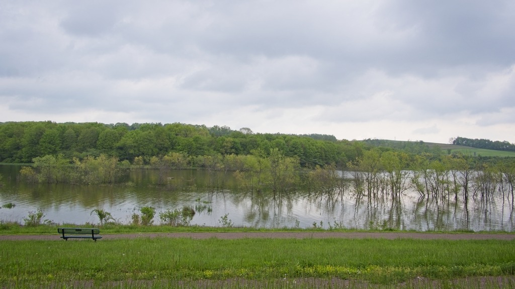
Lake Somerset is a 253-acre impoundment just north of Somerset (duh). It is owned by the Commonwealth of Pennsylvania and managed by the Fish and Boat Commission for public fishing and boating. The Commission’s Southwest Region Office is located at the lake. I stopped on a previous trip and couldn’t resist a return visit. It was great spot for some more Spring birding.
We will start at the north end and work our way south.A very nice fishing pier.These geese had several youngsters.
The Airglow Observatory sits atop a ridge on Laurel Mountain Road. It is in a state of poor repair, and there is some dispute as to whether it is abandoned. There is a large dome here for instrumentation. It looks like it was used for astronomical obesrving or weather monitoring.
I drove onto the site to take some pictures. As I was unsure whether I should be there, I did not stay long or look around the back of the building. There are other pictures online which can be found through search. There was no signage that I noticed when I was there, except for what was on the building. There are some antennae and lights on the building, which appear fairly modern and in good repair. The paint on some of the lower windows appears newer.
The building was constructed by the University of Pittsburgh under a NSF grant, with construction beginning in 1965, according to a press release. The purpose of the building was to study the atmosphere of Earth and the other planets, as stated in the release. Airglow is a faint emission of light by a planetary atmosphere. In the case of Earth’s atmosphere, this optical phenomenon causes the night sky never to be completely dark, even after the effects of starlight and diffused sunlight from the far side are removed. This phenomenon originates with self-illuminated gases and has no relationship with Earth’s magnetism or sunspot activity, causing aurorae.
From my stop at Laurel Summit State Park, I headed north toward Route 30 along the ridge of Laurel Mountain. Laurel Summit Road is a good, compacted gravel road and provided some good birdwatching and sightseeing opportunities.
More Spring flowers.This pond, just south of Laurel Mountain State Park, was most likely a water source for firefighting. The Laurel Mountain Warming Hut, base of operations for the cross country ski trails at Laurel Mountain.The entrance to Laurel Mountain State Park. The gate to access road was open but marked “authorized vehicles” only. I believe you can hike in during the off season.
Atop Laurel Ridge at close to 3,000 feet in elevation, Laurel Mountain State Park features a family-oriented downhill skiing area and beautiful views of the Ligonier Valley. Opened in 1939, Laurel Mountain was one of the first ski areas in Pennsylvania and was known as the “ski capital” of the state.
The history of ski areas in Pennsylvania state parks is a checkered one. After closing for business in 2005, Laurel Mountain has been operating again as a ski area since 2016. The ski assets of the park were purchased by Seven Springs Mountain Resort in November 2008 with the goal of reopening the slopes. The are operated under a contract with DCNR by the management of Seven Springs.Seven Springs signed a 10-year lease with DCNR in November 2009. This allowed the ski company to move ahead with plans to renovate and reopen the ski slopes. It was open for the 2024-25 season, and it appears it will be open next season.
Laurel Summit Road brings you out onto Route 30 just before a long downhill section heading west into Laughlintown.
On the last day of my trip to the Laurel Highland, I made a few stops at some covered bridges. Burkholder Covered Bridge was built in 1870 and uses the Burr Arch Truss in its construction. The bridge crosses Buffalo Creek in Brothers Valley Township, the length of the structure is 52 ft. and the width is 12 ft. It is in good condition and open to vehicle traffic.
Up next is the Packsaddle Covered Bridge. Packsaddle Covered Bridge (which is known as Doc Miller Covered Bridge in some sources) was built in 1870 by a builder that has been sadly lost to time. At 48 feet long, it is the shortest of the 10 covered bridges in Somerset County, PA. Don’t make my mistake and miss the small waterfall in Brush Creek under this bridge.
On my way back to the turnpike, I wanted to see the location of the Pittsburgh Zoo’s International Conservation Center. Unfortunately, it is not open to the public. It houses elephants that have been relocated from other facilities. This lovely church was on the way.
Located in Somerset County, Lake Somerset is a 253-acre impoundment owned by the Commonwealth of Pennsylvania and managed by the Fish and Boat Commission for public fishing and boating. The lake historically has stocked the lake with Channel Catfish, Muskellunge and Walleye fingerling. Fish habitat structures have been placed in the lake over the years a fish habitat improvement program. Boating is limited to boats powered by electric motors and un-powered boats. Two launch ramps are available along with associated parking facilities. Un-powered boats may be moored at the lake in accordance with Commission property regulations. The lake was extensively renovated beginning in 2017. The county has created a nature park around the lake. It seems like a lovely amenity for the region for birding and walking as well a boating and fishing.
There was a small boat concession operating at the lake.This fishing pier seemed quite popular.
Somerset County definitely has some different looking barn stars, This lacy looking white design seems to have been particularly popular.
I like the contrast between the barn and the wind turbine.Here’s another different style.These sheep were just chilling in the July heat.Here are some of my other favorite views around the county,
Somerset County is one of the places in Pennsylvania that has done an excellent job of preserving its covered bridges. They make nice side trips if you are visiting for skiing or other outdoor activity, Driving south in the county, one comes to Barronvale Covered Bridge. This bridge, also known as Barron’s Mill Bridge, is a covered bridge in Middlecreek Township crossing Laurel Hill Creek. At 162 feet 3 inches (49.45 m) it is the longest remaining covered bridge in Somerset County. It is 13 feet 10 inches (4.22 m) wide. The Burr truss bridge was built in 1902 by Cassimer Cramer.
The King’s Covered Bridge is in Middlecreek Township. It was built in 1802, and is a 127-foot-4-inch-long (38.81 m) Burr truss bridge, with an asbestos covered gable roof. The bridge also crosses Laurel Hill Creek and is easy to visit if you are also going to the Barronvale Bridge. It was added to the National Register of Historic Places in 1980. There is a nice picnic area adjacent to the bridge.
The Lower Humbert Covered Bridge, or the Faidley Covered Bridge, is an 126-foot-6-inch (38.56 m) Burr Arch truss covered bridge that crosses Laurel Hill Creek, in Lower Turkeyfoot Township. It was built in 1891 and was listed on the National Register of Historic Places on December 10, 1980. It has a more wooded setting in the base of a gorge.
This post is a sampling of some of the sites of Somerset County. The first stop is the Somerset Historical Center and Walters Mill Covered Bridge. The Center is a 150-acre rural history museum with exhibits, workshops, and educational programs dedicated to preserving the history of life in southwestern Pennsylvania from the region’s first farmers to the present day. It also serves as headquarters of the Historical & Genealogical Society of Somerset County. The Visitors Center houses permanent and changing exhibits as well as the Genealogical Research Library. I found it to be a good general source of information about the area, which was a life saver when my phone decided not to cooperate with me.
The Walter’s Mill Covered bridge has been relocated to the property.
The covered bridge was built in 1859 and originally crossed Coxes Creek, four miles south of the town of Somerset. Major repairs were made to the bridge in 1909, at which time laminated wood arches were added to the bridge’s original multiple kingpost truss system to accommodate heavier vehicles. Overtaken by developments and threatened with destruction, the bridge was moved to the Somerset Historical Center in the early 1960s. Extensively restored in 1986, the bridge remains open to pedestrian traffic.
Nearby is the Quecreek Mine Rescue site. On July 24, 2002 coal miners at the Quecreek Mine in Lincoln Township, owned by Black Wolf Coal Company, accidentally dug into the abandoned, poorly documented Saxman Coal / Harrison #2 Mine, flooding the room and pillar mine with an estimated 75 million US gallons (280,000 cubic meters) of water. Both the Saxman Mine and Quecreek Mine are in the Upper Kittanning coal seam. Fortunately, all nine trapped miners were rescued using a metal capsule structure lowered into the mine through a drilled hole. The incident garnered national attention, especially in the wake of the September 11 disaster and the crash of Flight 93 nearby in Shanksville.
The nearby Dormel Farm.
Driving further north, one can visit the Trostletown Covered Bridge, a historic covered bridge in Quemahoning Township. It was built in 1845, and is a 104-foot-long (32 m) Kingpost truss bridge, with half-height plank siding and an asbestos shingled gable roof. The bridge crosses Stony Creek. It is one of 10 covered bridges in Somerset County. It was added to the National Register of Historic Places in 1980.
The bridge is adjacent to an American Legion Post with an impressive display of hardware.
The town of Somerset, with a population of around 6,000, is the county seat of Somerset County. It is close to the Pennsylvania Turnpike and is a good jumping off point for the many varied activities that the Laurel Highlands area has to offer. The county is a beautiful mix of mountainous and agricultural areas and small town charm.
This is one of the more distinctive county courthouses in Pennsylvania, and it dominates the town skyline.The town contains some interesting late 19th and early 20th century architecture.I would take this building as an office.The Somerset Milling Co. is still a provider of feed and grain products.
Travelling from Bedford to Somerset, one encounters a string of covered bridges. First up is the Herline Covered Bridge, which is a wooden covered bridge which is located in Bedford County. It crosses the Juniata River, and is one of fifteen historic covered bridges which are located in Bedford County. Built in 1902, this historic structure is a 136-foot-long (41 m), Burr Truss bridge with a medium pitched gable roof. It was listed on the National Register of Historic Places in 1980.
Turners Covered Bridge is found off Route 31 in Bedford County. It is an 89 foot Burr Truss bridge, with low side panels and open sides. Construction date is believed to be approximately 1892. It spans the Raystown branch of the Juniata River. This half height style seems to have been popular in the area, as you will see in this post. The bridge is County owned and rests on stone abutments, reinforced with concrete.
I heard several killdeer calling from this field. They sounded like shorebirds, which makes sense since they are related to plovers.
The Colvin Covered Bridge has recently been refurbished. It is a multiple king-post bridge rather than the familiar Burr arch truss, resting on concrete abutments. Built in 1894, it crosses Shawnee Creek. The bridge is county owned and is 66 feet long. It was built in 1880.
Our trip now takes us into Somerset County. The New Baltimore Bridge is a covered bridge which crosses the Raystown Branch of the Juniata Rive. The Queen Post truss bridge was built in 1879 and is 86 feet 6 inches (26.37 m) in length and 12 feet (3.7 m) wide. It is one of 10 covered bridges in Somerset County.
I found these markers at covered bridges in Somerset County.
The Glessner Covered Bridge is a covered bridge in Somerset County near Shanksville. It was built in 1881, and is a 90-foot-long (27 m), multiple Kingpost truss bridge, with half-height plank siding and a tin covered gable roof. The bridge crosses Stonycreek River and is an interesting side trip if you are visiting the Flight 93 National Memorial. It was added to the National Register of Historic Places in 1980