

It now feels more like Spring in Chester County, although the calendar still says it’s Winter. The weather, however, can’t seem to make up its mind. We start with a few scenes around Kimberton.


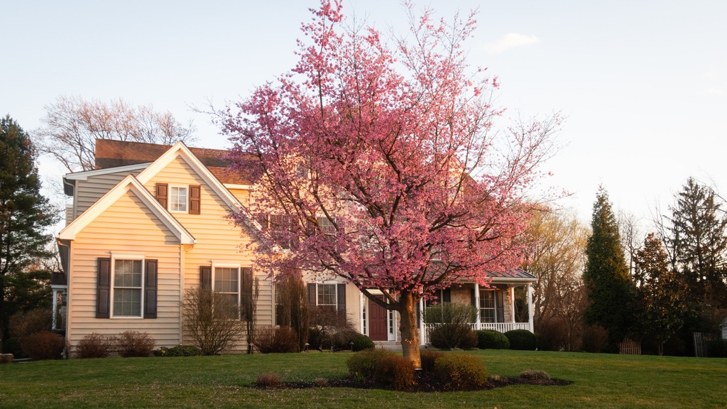
It now feels more like Spring in Chester County, although the calendar still says it’s Winter. The weather, however, can’t seem to make up its mind. We start with a few scenes around Kimberton.
Just west of Altoona, the Horseshoe Curve is a three-track railroad curve on Norfolk Southern Railway’s Pittsburgh Line in Blair County, Pennsylvania. The curve is roughly 2,375 feet (700 m) long and 1,300 feet (400 m) in diameter. Completed in 1854 by the Pennsylvania Railroad as a way to reduce the westbound grade to the summit of the Allegheny Mountains, it replaced the time-consuming Allegheny Portage Railroad, which was the only other route across the mountains for large vehicles. The curve was later owned and used by three Pennsylvania Railroad successors: Penn Central, Conrail, and Norfolk Southern.
Horseshoe Curve has long been a tourist attraction. A trackside observation park was completed in 1879. The park was renovated and a visitor center built in the early 1990s. The Railroaders Memorial Museum in Altoona manages the center, which has exhibits pertaining to the curve. The Horseshoe Curve was added to the National Register of Historic Places and designated as a National Historic Landmark in 1966. It became a National Historic Civil Engineering Landmark in 2004.


Heading north from the Altoona area, Prince Gallitzin State Park sits in the forested hills of the Allegheny Plateau surrounding sprawling Glendale Lake. Vistas offer scenic views of the 1,635-acre lake with its 26 miles of shoreline, which is a favorite of anglers and boaters. Campers flock to the large campground and also enjoy hiking and other outdoor activities. The varied habitats of the park make it a home for many types of wildlife, and a rest stop in the spring and fall migrations. One of the more developed parks, it boasts a marina along with its other facilities. A state game lands is adjacent. Here I saw two clueless ring necked pheasants just standing there and enjoying the view of the traffic on Beaver Valley Road.


The 2,981-acre Yellow Creek State Park is in Indiana County along one of the first “highways” in the state, the Kittanning Path. This trail was used by the Delaware and Shawnee nations and by early settlers. Today, visitors enjoy the sand beach, picnicking, and educational and recreational programs. The 720-acre Yellow Creek Lake is a destination for boaters and anglers. The lake and park are an important rest stop for migrating birds. The park is named for Yellow and Little Yellow creeks, which flow into the lake. Both creeks contain yellow clay in their banks and bottoms.


A day out in the rural areas of Lancaster County will provide many encounters with horse drawn buggies, whether in motion or stationery. Sundays tend to be particularly busy, with people going to church or visiting neighbors.


Today’s visit to Lancaster County includes some covered bridged and nearby views. First up is Weaver’s Mill Covered Bridge, which spans the Conestoga River. The 85-foot-long (26 m), 15-foot-wide (4.6 m) bridge was built in 1878 by B. C. Carter and J. F. Stauffer. It is also known as Isaac Shearer’s Mill Bridge. The bridge has a single span, wooden, double Burr arch trusses design with the addition of steel hanger rods. It is painted red, the traditional color of Lancaster County covered bridges, on both the inside and outside. Both approaches to the bridge are painted in the traditional white color. It was listed on the National Register of Historic Places in 1980.


The Bitzer’s Mill Covered Bridge is a covered bridge that is also on the Conestoga River. It is the oldest bridge in the county still in use. A county-owned and maintained bridge, it is also called Martin’s Mill Bridge, Eberly’s Cider Mill Covered Bridge, and Fiand’s/Fiantz’s Covered Bridge.
The bridge has a single span, wooden, double Burr arch trusses design with the addition of steel hanger rods. The deck is made from oak planks. Added later, secondary steel I-beams support the bridge from underneath. The bridge is currently unpainted. It was formerly painted red on the outside, and the inside of the bridge was not painted. Both approaches to the bridge were painted white. In July 2006, the bridge sustained some damage to its sides including some missing or broken panels. The bridge was added to the National Register of Historic Places in 1980.
The bridge was built in 1846 by George Fink and Sam Reamsnyder at a cost of $1,115. They used a single span, wooden, double Burr arch truss construction. The bridge has historically been referred to by a number of names that reflected the various mill owners. In 1962, it was proposed to replace the bridge with a concrete span, but the plan was discontinued after much public outcry.


The Keller’s Mill Covered Bridge is a covered bridge that spans Cocalico Creek. It is also sometimes known as Guy Bard Covered Bridge (after a local jurist) and Rettew’s Covered Bridge (after the person that Rettew’s Road is named). Due to heavy road traffic on the aging, one-lane bridge, construction on a new steel and concrete bridge to bypass the covered bridge occurred in the summer of 2006. The bridge was disassembled and reassembled a few miles downstream to replace an existing one lane bridge. It was located at 40°10′11.4″N 76°12′16.8″W (40.16983, −76.20467) before being disassembled.
Keller’s Mill Covered Bridge was originally built by Elias McMellen in 1873 at a cost of US$2,075. After being swept away in flooding, the bridge was rebuilt in 1891, again by McMellen. It stayed there until it was disassembled and moved in 2006. The bridge was reconstructed in 2009. The bridge was reopened on Middle Creek Road in December, 2010. Keller’s Mill Covered Bridge has a single span, wooden, double Burr arch trusses design with the addition of steel hanger rods. The deck is made from oak planks. The bridge is the only all white bridge in the county, with no red. In fact, just about all covered bridges were whitewashed both inside and out. It is the only bridge to have survived the transition from whitewashing to the red color commonly used in barns throughout the county. The bridge is not painted on the inside.


The Ephrata Cloister or Ephrata Community was a religious community, established in 1732 by Johann Conrad Beissel at Ephrata, Lancaster County. The grounds of the community are now owned by the Commonwealth of Pennsylvania and are administered by the Pennsylvania Historical and Museum Commission. The Cloister’s website can be found at https://ephratacloister.org and provides the following information:
Conrad Beissel, Ephrata’s founder, came to the site in 1732 seeking to live as a hermit following his own religious ideas. He believed earthly life should be spent preparing to achieve a spiritual union with God at the Second Coming he felt would soon occur. By the early 1750s, nearly 80 celibate Brothers and Sisters were housed in impressive Germanic log, stone, and half-timbered buildings. At the same time, nearly 200 family members known as Householders, occupied nearby homes and farms.
Celibate members followed a life of work balanced with hours of private prayer. Wearing white robes, they adopted sparse diets, and slept little, all in an effort to provide discipline as they prepared for an anticipated heavenly existence. Labors included farming, papermaking, carpentry, milling, and textile production. The Cloister was known for the German calligraphic art of Frakturschriften, created in a distinctive style considered the first of this folk art produced in America, self-composed a cappella music written using Beissel’s rules for four-part harmony (with over one-thousand original compositions), and an ambitious printing establishment creating works for the use of the community and neighbors, including the translation and publication of the 1500 page Martyrs Mirror for the Mennonites, the largest book printed in colonial America.
The Society declined after the death of the charismatic Beissel in 1768. The last celibate member died in 1813 and the next year the remaining Householders incorporated into the German Seventh Day Baptist Church. Members continued to live and worship in the Cloister buildings until the close of the Church in 1934. Marie Kachel Bucher, the last surviving resident of the Ephrata Cloister, died on July 27, 2008, at the age of 98.
Here is a look at the exterior of the buildings. There was an event going on that Day called “Charter Day” which was wrapping up as I was arriving in late afternoon.


An day drive around the lovely Kimberton area of Chester County. As they say, “A picture is worth a thousand words.”


This October I was fortunate to take a trip to Maine, Nova Scotia and Quebec. Much of the topography of the inland areas, and the fall color, remind me of Pennsylvania. First up is a boat trip from Bar Harbor, Maine. This part of the Maine coast from Bar Harbor to Somes Sound is dotted with the “cottages” of the rich and famous.


The trip was themed around the lighthouses of the Bay of Maine near the Mount Desert Island shore.


Here are some boats, buoys, and critters along the way, along with a few looks at Mount Desert Island from the sea.


This is a weekend to remember all our blessings – the people, places and things that make life worthwhile. I am grateful that this Commonwealth has such and abundance of natural beauty and wonderful people,

Lycoming County has a total of four covered bridges. I visited two of them on my way home from Potter County.
The Buttonwood Bridge (also known as the Blockhouse Bridge) was built in 1898 with the structure spanning Blockhouse Creek. It uses a queen post with king post truss and is 74 feet 2 inches (22.6 m) long. The bridge is in good condition with a new wood shingled roof and pressure treated floor. The structure is open to traffic all year long. The bridge was placed on the National Register of Historic Places in 1980 and had a major restoration in 1998. It is the shortest and most heavily used of the three covered bridges remaining in Lycoming County.


The next bridge to the south was the Cogan House Bridge. This bridge was built in 1877 of the Burr Arch design with a structure length of 94 feet crossing Larry’s Creek. Cogan House bridge is open to traffic, and leads to a dead end private drive near the game lands. The bridge was placed on the National Register of Historic Places in 1980, and had a major restoration in 1998. The Cogan House bridge is named for the township and village of Cogan House, and is also known by at least four other names: Buckhorn, Larrys Creek, Day’s, and Plankenhorn.
The Cogan House Covered Bridge was constructed by a millwright who assembled the timber framework in a field next to the sawmill, before it was reassembled at the bridge site. It was the only bridge on Larrys Creek that survived the flood of June 1889, and one of only a handful that were left intact in the county. Although the bridge used to carry a steady flow of tannery and sawmill traffic, the clearcutting of the surrounding forests meant the end of those industries by the early 20th century.


I left Austin and proceeded south to Sizerville State Park. This park reminds me of Hyner Run or Reeds Gap. It is a quiet park with a small campground and a pool. Alas, the pool at Reeds Gap is gone, but this type of park remains one of my favorites. The 368 acre Sizerville is surrounded by Elk State Forest and near large blocks of additional state forest land. If it wasn’t so far, I’d like to come back here.


I then made the long journey to Kettle Creek State Park. In retrospect, I should have done this the day before as continuation of my trip to Ole Bull, but now I know better. The park consists of 1,793 acres along Kettle Creek in western Clinton County. The park is in a valley surrounded by mountainous terrain and wilderness. Many of the existing recreational facilities arose from a joint flood control project developed by the U.S. Army Corps of Engineers and the former Pennsylvania Department of Environmental Resources. The park offers camping, boating, hunting, fishing, hiking, and other activities.


I thought I might be able to save some time getting to Sinnemahoning State Park by driving up to Kettle Creek Vista then cutting across the ridge and down the other side. Of course there were no roads down into the other valley, because there was another lake, with (you guessed it) another dam.

I made the trek back down the valley to highway north to Sinnemahoning State Park. The park, located near the center of the Pennsylvania Wilds’ scenic steep valleys region, encompasses 1,910 acres of beautiful scenery and outstanding wildlife habitat. Situated in Cameron and Potter counties, the park is nestled between the green-shouldered ridges of Pennsylvania’s Elk State Forest and Susquehannock State Forest. The park is long and narrow and includes lands on both sides of First Fork Sinnemahoning Creek — a major tributary to the Sinnemahoning Creek. At the southern end of the park, a 145-acre reservoir created by the George B. Stevenson dam provides fishing and boating opportunities. There is a campground and excellent wildlife viewing opportunities, including elk, bear, and large variety of birds.


