One of Pennsylvania’s iconic state parks is Kinzua Bridge. There is a large visitor center and an opportunity to walk out onto the old railroad viaduct with impressive views of the valley below.
The Viaduct was once the longest and tallest railroad structure at 2,053 feet long and 301 feet high. It was partially destroyed by a tornado during 2003. Reinvented as a pedestrian walkway in 2011, visitors can stroll 600 feet out on the remaining support towers, peer miles out into the Kinzua Gorge, and gaze down through the partial glass platform at the end of the walkway. The Kinzua Bridge State Park Visitor Center features great views, self-guiding exhibits, and information about the surrounding area.
A view to the valley below. This photo really doesn’t do it justice.Some exhibits in the Visitor’s Center.A unexpected photo op – the Swedish Viking Ship sculpture in nearby Mt. Jewett.
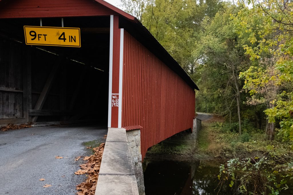
I swung by some bridges in Northumberland County on my way to visit relatives. The Himmel’s Church Covered Bridge crosses over Schwaben Creek on Middle Creek Road, east of Rebuck, Northumberland County. It was built in 1874, and rehabilitated in 1973. It is a King post truss style wooden covered bridge, with a length of 44 feet. It currently remains in use to automobile traffic.
The Bridge is located near the site of the Schwaben Creek werewolf, according to local folklore. It was added to the National Register of Historic Places on August 8, 1979. It has a unique candy stripe color scheme in addition to the King post architecture which gives it a distinctive look.
Keefer Station Covered Bridge is a historic wooden covered bridge located at Upper Augusta Township in Northumberland County. It is a 109 foot long, Burr arch truss bridge, constructed in 1888. It crosses the Shamokin Creek. It was listed on the National Register of Historic Places in 1979. The open spaces under the eaves also give this bridge a unique look.
A drive through Berks and Schuylkill Counties this past Autumn provided some scenic views. First up is the Zimmerman Covered Bridge in Schuylkill County. Originally built in 1880, it is 65 feet long.
Zimmerman Covered BridgeThe familiar Burr Arch Truss construction.A neat old shed.Are you looking at us?These cows do not seem to care.
The Dreibelbis Station Bridge is a 172 foot long Burr arch truss covered bridge spanning Maiden Creek south of Lenhartsville, Berks County. The bridge was built in 1869 and was added to the National Register of Historic Places on February 23, 1981. Another Berks bridge with a hex sign – I love it.
A pretty farm property
Kutz’s Mill Bridge is a historic wooden covered bridge located at Greenwich Township in Berks County, Pennsylvania. It is a 93 foot long, Burr Truss bridge, constructed in 1854. It crosses the Sacony Creek. As the name implies, it leads to the Kutz Mill. It was listed on the National Register of Historic Places in 1981.
Kutz’s Mill Covered BridgeKutz’s Mill
The Rock Covered Bridge is a single-span Burr arch truss 55 feet 7 inches over Little Swatara Creek in Schuylkill County.
Shikellamy State Park is an unusual park in that it contains two distinctly different sections. It also affords great views of the two branches of the Susquehanna River (the West Branch and the North Branch ). The Park is in both Union and Northumberland counties. The 54-acre Shikellamy Marina is on the southern tip of Packers Island at the confluence of the West Branch and North Branch Susquehanna River, and offers hiking and biking trails, a marina, and boat launch. The 78-acre Shikellamy Overlook is on the western shore of the Susquehanna River. A 360-foot cliff overlooks the confluence of the two branches of the river.
Although the marina area seemed more popular with Labor Day party goers, I was more impressed with the views on the overlook side.
A look toward the Marina.A look down over the edge.The West Branch on the left.The town of Northumberland.
The Marina Section provides great access to the water as well as picnicking opportunities.
Heading south from Tioga County to find a couple of the more urban state parks, I first went in search of a covered bridge in Lycoming County that I had missed on a previous trip. This bridge was on private property, so only a distant shot was possible. The James S. Fink covered bridge was built in 1986 utilizing a Stringer truss design. It crosses Larry’s creek in Anthony Township. The structure is 62 feet long and is open to vehicle traffic, but it is on a private road.
Susquehanna State Park is a 20-acre riverfront recreational area is in the city of Williamsport. The Williamsport Chamber of Commerce operates this park in cooperation with the state. It is primarily a location for river access for boating and fishing. There are also opportunities for picnicking, wildlife watching, and gongoozling (google it). It is next to the boarding point for the riverboat Hiawatha.
Labor Day chill by the river.The boat rampThe Lance Corporal Abram Howard Memorial Bridge
Milton State Park is an 82-acre island on the West Branch Susquehanna River, between the boroughs of Milton and West Milton. The northern half of the park has day use facilities and the southern half remains in a wooded state for hiking and nature study. It also has a boat launch, playground and extensive soccer fields.
This post features a quick series of covered bridges in northwestern Lancaster County, the home of the largest number of covered bridges in the state. The first up is Schenk’s Mill Covered Bridge (or Shenk’s Mill Covered Bridge). It is a covered bridge that spans Big Chiques Creek. The bridge has a single span, wooden, double Burr arch truss design with the addition of steel hanger rods. The deck is made from oak planks. It is painted red and both approaches to the bridge are painted white. It is one of only 3 covered bridges in the county with horizontal side boards. It is listed on the National Register of Historic Places. The bridge was built in 1847 by Charles Malhorn and Levi Fink. It was rebuilt in 1855 and is 80 feet long.
Shenk’s Mill Covered Bridge
The Shearer’s Covered Bridge is a covered bridge that also spans Big Chiques Creek. The bridge has a single span, wooden, double Burr arch truss design. It is the only covered bridge in the county painted entirely in red in Lancaster County, on both the inside and outside, including both approaches. The other all red bridge, Pool Forge Covered Bridge, is only painted on the outside. It is one of only 3 covered bridges in the county with horizontal side boards. It is listed on the National Register of Historic Places. The bridge was built in 1847 by Jacob Clare. It was rebuilt in 1855 and stayed its original location until it was moved in 1971 to its present location in the Manheim Memorial Park. It is 86 feet long.
Shearer’s Mill Covered Bridge
The Pinetown Bushong’s Mill Covered Bridge is a covered bridge that spans the Conestoga River. The bridge is also known as the Pinetown Amish Covered Bridge, Pinetown Covered Bridge, Nolte’s Point Mill Bridge and Bushong’s Mill Bridge.
The bridge has a single span, wooden, double Burr arch truss design with the addition of steel hanger rods. The deck is made from oak planks. It is listed on the National Register of Historic Places. The bridge was built in 1867 by Elias McMellen at a cost of $4,500. In 1972, it was destroyed as a result of flooding caused by Hurricane Agnes. Due to a tremendous response of area residents who signed a petition for its reconstruction, it was among the first covered bridges to be restored after Agnes. In the spring of 1973, the bridge was rebuilt by the nearby Amish. To prevent damage due to future flooding, they raised the bridge to 17 feet 6 inches above the average water line. Lititz Run joins the Conestoga River at this site. It is 124 feet long.
Pinetown Amish Covered Bridge
The Kauffman’s Distillery Covered Bridge, or Sporting Hill Bridge, is a covered bridge that spans Chiques Creek. The bridge has a single span, wooden, double Burr arch truss design with the addition of steel hanger rods. The deck is made from oak planks.
It is registered on the National Register of Historic Places. Kauffman’s Distillery Covered Bridge was originally built in 1857 at a cost of $1,185 by James C. Carpenter. The bridge was named after the Kauffman’s Distillery Mill which operated in the late 1800s. In 1874, the bridge was rebuilt by Elias McMellen at a cost of $1,620. It is 84 feet long.
Kauffman’s Distillery Covered Bridge
Hunsecker’s Mill Covered Bridge is a covered bridge located in Lancaster County, Pennsylvania, United States. The bridge has a single span, wooden, double Burr arch truss design. The bridge, which spans the Conestoga River, is 180 feet long, making it the longest single span covered bridge in the county. The original bridge was built in 1843 by John Russell at a cost of $1,988. It is a double Burr Arch truss system. It has been swept away in flooding numerous times, most recently in 1972 after Hurricane Agnes. Waters lifted the original structure off its abutments and carried it downstream. In 1973, following destruction from the hurricane, it was rebuilt at a cost of $321,302. While Schenck’s covered bridge is one of 3 bridges with horizontal siding boards, the Hunsecker’s Mill bridge may be the only one in Lancaster County with horizontal floor boards which give a unique vibration upon crossing. A detailed scale model (~7′ long), complete with stone abutments, was donated to the Lancaster Mennonite Historical Society and may be available for viewing.
Hunsecker’s Mill Covered Bridge
Erb’s Mill Covered Bridge is a covered bridge that spans Hammer Creek. The bridge has a single span, wooden, double Burr arch truss design with the addition of steel hanger rods. The deck is made from oak planks. It was added to the National Register of Historic Places in 1980. The bridge was originally built in 1849 for a cost of $700. It was built on the Erb family’s tract of land in the farming region along Hammer Creek. In 1887 the bridge was rebuilt by John G. Bowman for $1744. It is 70 feet long.
Erb’s Mill Covered Bridge
The Bucher’s Mill Covered Bridge (or Butcher’s Mill Covered Bridge) is a covered bridge that spans Cocalico Creek. After the Landis Mill Covered Bridge, it is the second shortest covered bridge in the county. The bridge has a single span, wooden, double Burr arch truss design with the addition of steel hanger rods. The deck is made from oak planks.
It is registered on the National Register of Historic Places. Bucher’s Mill Covered Bridge was built in 1891 by Elias McMellen, using single span, wooden, double Burr arch truss construction, at a cost of $1167. A year later, in 1892, the bridge was damaged heavily in a flood and was rebuilt by McMellen for $1025. At only 64 feet long, it is one of the shortest covered bridges in Lancaster County.
Adams County is home to four covered bridges. A visit to the bridges provides a focus for a drive outside Gettysburg for visitors to the area. As usual, covered bridges look best to me in Autumn.
The first up the Anderson Farm Covered Bridge. The builder of this bridge is unknown, the length is 79 ft., and the width is 14 ft. The bridge appears to be in very good shape and closed to all traffic. The bridge is used for storage by the present owners of the property This structure originally spanned Mud creek. It was moved to the point where it is today by a farmer named Anderson.
Heikes Covered Bridge is located approximately 2.5 miles north of Heidlersburg, between Tyrone and Huntington Township. The structure was built in 1892 and uses the Burr truss, and the builder is unknown. The bridge crosses Bermudian Creek and is 67 ft. long and 14 ft. wide. The bridge is not open to any traffic and is located on private land.
Jack’s Mountain Bridge is located on State Route 3021, Jack’s Mountain Rd., approximately 1.5 miles south west of Fairfield in Hamiltonban Township. The bridge was built in 1890 by Joseph Smith using the Burr truss. The structure is 75 ft. long and 14 ft. wide and crosses Tom’s Creek. The state owns this bridge, and it is open to all traffic. This is the only bridge in Adams County that is opened to vehicular traffic. The bridge has a red light at each end to control the traffic flow on this one lane structure.
Finally, the Sachs Covered Bridge is very near Gettysburg National Military Park. It is located on Twp. Route 405, Pumping Station Road, in Freedom Township, just south of State Route 305 and west of the Eisenhauer National Historic site and and Gettysburg National Military Park. The bridge was built in 1854 by David Spooner using the Town truss and and utilizing one span. The structure is 100 ft. long and 15 ft. wide, and it is only open to foot traffic. The bridge crosses Marsh Creek and is owned by Gettysburg Battlefield Preservation Association.
The bridge was known as Sauck’s during the Civil War, it was built using oak and pine. The bridge was repaired in 1997 after heavy rains washed the bridge from it’s foundation and carried it approximately one hundred yards downstream.
On July 3rd and 4th, 1863 , the bridge was used by a portion of the Confederate army, in retreat out of Gettysburg, but is said to have been used by both armies during the time of the Gettysburg conflict. Robert E. Lee had split his army into 2 sections, with one headed to Northwest toward Cashtown, while the other crossed Sauck’s Bridge and headed Southwest. The bridge is known to have been the site of a triple hanging at one end, and in close proximity to a crude post battle field hospital, the Sauck’s Covered Bridge is a favorite of ghost hunters.
What do you think they are talking about?Out fishing on a Fall day.
A bonus location is the historic Round Barn and Farmer’s Market on Cashtown Road, which I have featured on this blog before. While at the market, I picked up some delicious apple cider, cider donuts, and fresh apples. The market features many kinds of apples which are difficult to find.
Franklin County, Pennsylvania is home to two covered bridges. It was great to seem them in the Autumn, which is the Commonwealth’s best season (in my opinion. of course).
First up is the Martins Mill or Shindle Bridge which is reported to be the longest remaining Town truss covered bridge in Pennsylvania. It was reconstructed after the Hurricane Agnes flood of 197, but it is now closed to all traffic. It is still open to foot and bike trail users. The bridge was built in 1839 by Jacob Shirk. The length is 207 ft. with a width of 16 ft.. it crosses Conococheague Creek in Franklin County.
One the way to this bridge, I spotted some interesting cattle:
The Witherspoon Covered Bridge is the second covered bridge in Franklin County. The bridge was built in 1883 by S. Stouffer. It utilizes the Burr Truss in its construction. The bridge’s length is 87 ft., and the width is 14 ft. it crosses Licking Creek in Montgomery Township.
Looming over the town of Nicholson, Pennsylvania is the Tunkhannock Creek Viaduct, a railroad bridge completed in 1915. It is a concrete deck arch bridge on the Nicholson Cutoff rail segment of the Norfolk Southern Railway Sunbury Line that spans Tunkhannock Creek. Measuring 2,375 feet (724 m) long and 240 feet (73.15 m) tall when measured from the creek bed (300 feet (91.44 m) from bedrock), it was the largest concrete structure in the world when completed in 1915 and still merited “the title of largest concrete bridge in America, if not the world” 50 years later. Built by the Delaware, Lackawanna and Western Railroad, the bridge is owned today by Norfolk Southern Railway and is still used daily for regular through freight service. Apparently almost half of the bulk of this behemoth is underground, in the form of bridge pillars up to 138 feet (142 m) below ground.
The bridge was listed on the National Register of Historic Places on April 11, 1977. In 1975, the American Society of Civil Engineers or ASCE designated the bridge as a Historic Civil Engineering Landmark. ASCE recognized the bridge as “not only a great feat of construction skill” but also a “bold and successful departure from contemporary, conventional concepts of railroad location in that it carried a mainline transversely to the regional drainage pattern, effectively reducing the distance and grade impediments…”
The bridge towers over the town of Nicholson.A view further upstream.The cows don’t seem to notice the vast structure.
I also swung by Lackawanna State Park on my way back from the bridge. The 1,445-acre park is ten miles north of Scranton. The focus is the 198-acre Lackawanna Lake, which is surrounded by picnic areas and multi-use trails winding through forest. Boating, camping, fishing, mountain biking, and swimming are popular recreation activities here.
I’ve always wanted a canoe mooring on a lake.At least these geese don’t mind the weather.Another rainy late spring day ….Great spot for a picnic and a boat trip.
Kurtz’s Mill Covered Bridge is a covered bridge over Mill Creek in Lancaster County Central Park. The bridge is also known as the County Park Covered Bridge, Baer’s Mill Covered Bridge, Isaac Baer’s Mill Bridge, Keystone Mill Covered Bridge, Binder Tongue Carrier Covered Bridge, and Mill 2A Covered Bridge (that’s a lot of names). The bridge is used by road traffic from within the park to access a picnic pavilion.
Kurtz’s Mill Covered Bridge
The bridge has a single span, wooden, double burr arch trusses design with the addition of steel hanger rods. The deck is made from oak planks. It is painted red, the traditional color of Lancaster County covered bridges, on both the inside and outside. Both approaches to the bridge are painted in red with white trim. It has a 94 foot span.
The span of the bridge from the trail below. Excuse the backlighting.
The bridge was built in 1876 by W. W. Upp over the Conestoga River. In 1972, it was damaged by the floodwaters caused by Hurricane Agnes. It was repaired by David Esh in 1975 and moved to its present location in the Lancaster County Park over Mill Creek, a tributary of the Conestoga River. Unlike most historic covered bridges in the county, it is not listed on the National Register of Historic Places.